You are here: Home > Network List > AK - Alaska Regional Network Stations List
> Station E21K Killik River, AK, USA > Earthquake Result Viewer
E21K Killik River, AK, USA - Earthquake Result Viewer
| Earthquake location: |
Northeastern India |
| Earthquake latitude/longitude: |
26.8/92.4 |
| Earthquake time(UTC): |
2021/04/28 (118) 02:21:25 GMT |
| Earthquake Depth: |
29 km |
| Earthquake Magnitude: |
6.0 mww |
| Earthquake Catalog/Contributor: |
NEIC PDE/us |
|
| Network: |
AK Alaska Regional Network |
| Station: |
E21K Killik River, AK, USA |
| Lat/Lon: |
68.44 N/153.97 W |
| Elevation: |
653 m |
|
| Distance: |
73.5 deg |
| Az: |
20.685 deg |
| Baz: |
301.315 deg |
| Ray Param: |
0.05293402 |
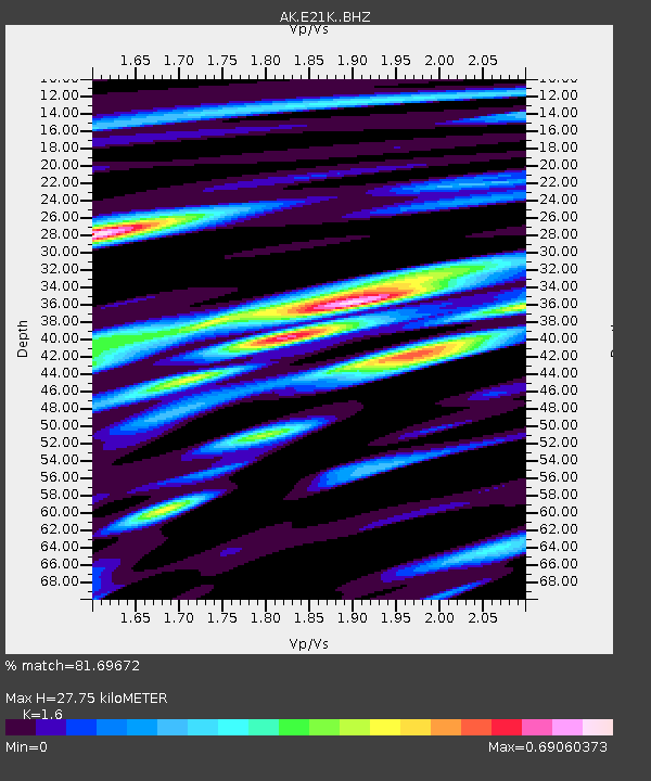
| Estimated Moho Depth: |
27.75 km |
| Estimated Crust Vp/Vs: |
1.60 |
| Assumed Crust Vp: |
6.221 km/s |
| Estimated Crust Vs: |
3.888 km/s |
| Estimated Crust Poisson's Ratio: |
0.18 |
|
| Radial Match: |
81.69672 % |
| Radial Bump: |
400 |
| Transverse Match: |
82.4875 % |
| Transverse Bump: |
400 |
| SOD ConfigId: |
24334971 |
| Insert Time: |
2021-05-12 02:27:07.028 +0000 |
| GWidth: |
2.5 |
| Max Bumps: |
400 |
| Tol: |
0.001 |
|

Signal To Noise
| Channel | StoN | STA | LTA |
| AK:E21K: :BHZ:20210428T02:32:24.419972Z | 23.385002 | 1.8211933E-6 | 7.7878695E-8 |
| AK:E21K: :BHN:20210428T02:32:24.419972Z | 2.4302843 | 2.1199772E-7 | 8.7231655E-8 |
| AK:E21K: :BHE:20210428T02:32:24.419972Z | 8.118547 | 4.2125205E-7 | 5.1887614E-8 |
| Arrivals |
| Ps | 2.8 SECOND |
| PpPs | 11 SECOND |
| PsPs/PpSs | 14 SECOND |


