You are here: Home > Network List > IU - Global Seismograph Network (GSN - IRIS/USGS) Stations List
> Station XMAS Kiritimati Island, Republic of Kiribati > Earthquake Result Viewer
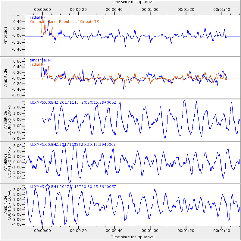
XMAS Kiritimati Island, Republic of Kiribati - Earthquake Result Viewer
*The percent match for this event was below the threshold and hence no stack was calculated.
| Earthquake location: |
Loyalty Islands |
| Earthquake latitude/longitude: |
-22.0/168.9 |
| Earthquake time(UTC): |
2017/11/15 (319) 20:23:05 GMT |
| Earthquake Depth: |
8.0 km |
| Earthquake Magnitude: |
5.4 Mww |
| Earthquake Catalog/Contributor: |
NEIC PDE/us |
|
| Network: |
IU Global Seismograph Network (GSN - IRIS/USGS) |
| Station: |
XMAS Kiritimati Island, Republic of Kiribati |
| Lat/Lon: |
2.04 N/157.45 W |
| Elevation: |
20 m |
|
| Distance: |
40.6 deg |
| Az: |
58.327 deg |
| Baz: |
232.241 deg |
| Ray Param: |
$rayparam |
*The percent match for this event was below the threshold and hence was not used in the summary stack. |
|
| Radial Match: |
65.86095 % |
| Radial Bump: |
400 |
| Transverse Match: |
55.047874 % |
| Transverse Bump: |
400 |
| SOD ConfigId: |
2429771 |
| Insert Time: |
2017-11-29 20:25:13.138 +0000 |
| GWidth: |
2.5 |
| Max Bumps: |
400 |
| Tol: |
0.001 |
|
Signal To Noise
| Channel | StoN | STA | LTA |
| IU:XMAS:00:BHZ:20171115T20:30:15.394006Z | 1.2933787 | 9.87748E-7 | 7.636959E-7 |
| IU:XMAS:00:BH1:20171115T20:30:15.394006Z | 1.9230046 | 2.7341482E-6 | 1.4218105E-6 |
| IU:XMAS:00:BH2:20171115T20:30:15.394006Z | 1.5600816 | 1.5732994E-6 | 1.0084725E-6 |
| Arrivals |
| Ps | |
| PpPs | |
| PsPs/PpSs | |


