You are here: Home > Network List > IU - Global Seismograph Network (GSN - IRIS/USGS) Stations List
> Station GRFO Grafenberg, Germany > Earthquake Result Viewer
GRFO Grafenberg, Germany - Earthquake Result Viewer
| Earthquake location: |
Northeastern India |
| Earthquake latitude/longitude: |
26.8/92.4 |
| Earthquake time(UTC): |
2021/04/28 (118) 02:21:25 GMT |
| Earthquake Depth: |
29 km |
| Earthquake Magnitude: |
6.0 mww |
| Earthquake Catalog/Contributor: |
NEIC PDE/us |
|
| Network: |
IU Global Seismograph Network (GSN - IRIS/USGS) |
| Station: |
GRFO Grafenberg, Germany |
| Lat/Lon: |
49.69 N/11.22 E |
| Elevation: |
384 m |
|
| Distance: |
64.6 deg |
| Az: |
314.704 deg |
| Baz: |
78.04 deg |
| Ray Param: |
0.058810275 |
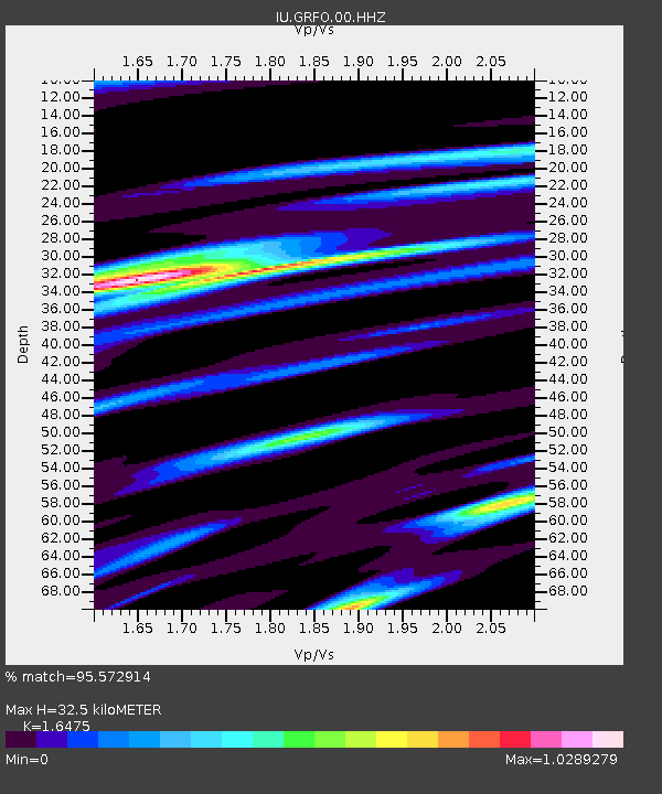
| Estimated Moho Depth: |
32.5 km |
| Estimated Crust Vp/Vs: |
1.65 |
| Assumed Crust Vp: |
6.182 km/s |
| Estimated Crust Vs: |
3.753 km/s |
| Estimated Crust Poisson's Ratio: |
0.21 |
|
| Radial Match: |
95.572914 % |
| Radial Bump: |
400 |
| Transverse Match: |
86.963425 % |
| Transverse Bump: |
389 |
| SOD ConfigId: |
24334971 |
| Insert Time: |
2021-05-12 02:34:05.256 +0000 |
| GWidth: |
2.5 |
| Max Bumps: |
400 |
| Tol: |
0.001 |
|

Signal To Noise
| Channel | StoN | STA | LTA |
| IU:GRFO:00:HHZ:20210428T02:31:29.088001Z | 42.10568 | 3.32148E-6 | 7.888437E-8 |
| IU:GRFO:00:HH1:20210428T02:31:29.088001Z | 8.668263 | 4.923328E-7 | 5.6797166E-8 |
| IU:GRFO:00:HH2:20210428T02:31:29.088001Z | 16.81633 | 1.7999666E-6 | 1.0703683E-7 |
| Arrivals |
| Ps | 3.6 SECOND |
| PpPs | 13 SECOND |
| PsPs/PpSs | 17 SECOND |


