You are here: Home > Network List > TA - USArray Transportable Network (new EarthScope stations) Stations List
> Station F17K Baldwin Penninsula, AK, USA > Earthquake Result Viewer
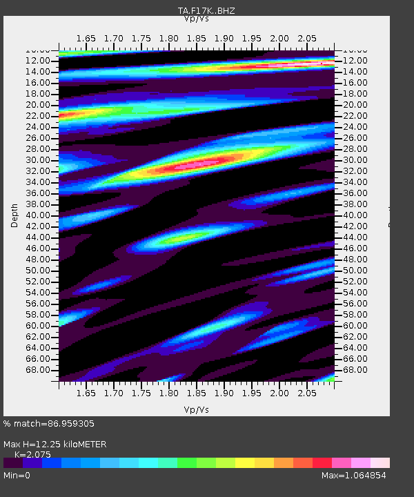
F17K Baldwin Penninsula, AK, USA - Earthquake Result Viewer
| Earthquake location: |
Northeastern India |
| Earthquake latitude/longitude: |
26.8/92.4 |
| Earthquake time(UTC): |
2021/04/28 (118) 02:21:25 GMT |
| Earthquake Depth: |
29 km |
| Earthquake Magnitude: |
6.0 mww |
| Earthquake Catalog/Contributor: |
NEIC PDE/us |
|
| Network: |
TA USArray Transportable Network (new EarthScope stations) |
| Station: |
F17K Baldwin Penninsula, AK, USA |
| Lat/Lon: |
66.44 N/161.25 W |
| Elevation: |
51 m |
|
| Distance: |
72.0 deg |
| Az: |
23.931 deg |
| Baz: |
295.562 deg |
| Ray Param: |
0.05393852 |
| Estimated Moho Depth: |
12.25 km |
| Estimated Crust Vp/Vs: |
2.08 |
| Assumed Crust Vp: |
6.276 km/s |
| Estimated Crust Vs: |
3.024 km/s |
| Estimated Crust Poisson's Ratio: |
0.35 |
|
| Radial Match: |
86.959305 % |
| Radial Bump: |
400 |
| Transverse Match: |
80.55715 % |
| Transverse Bump: |
400 |
| SOD ConfigId: |
24334971 |
| Insert Time: |
2021-05-12 02:36:53.574 +0000 |
| GWidth: |
2.5 |
| Max Bumps: |
400 |
| Tol: |
0.001 |
|

Signal To Noise
| Channel | StoN | STA | LTA |
| TA:F17K: :BHZ:20210428T02:32:15.450001Z | 21.618967 | 1.746813E-6 | 8.080002E-8 |
| TA:F17K: :BHN:20210428T02:32:15.450001Z | 2.6866198 | 4.0933247E-7 | 1.5235966E-7 |
| TA:F17K: :BHE:20210428T02:32:15.450001Z | 4.2732034 | 4.983054E-7 | 1.1661166E-7 |
| Arrivals |
| Ps | 2.2 SECOND |
| PpPs | 5.8 SECOND |
| PsPs/PpSs | 8.0 SECOND |


