You are here: Home > Network List > TA - USArray Transportable Network (new EarthScope stations) Stations List
> Station I20K Naaghedeneel ne tl'uh kk'aat, AK, USA > Earthquake Result Viewer
I20K Naaghedeneel ne tl'uh kk'aat, AK, USA - Earthquake Result Viewer
| Earthquake location: |
Northeastern India |
| Earthquake latitude/longitude: |
26.8/92.4 |
| Earthquake time(UTC): |
2021/04/28 (118) 02:21:25 GMT |
| Earthquake Depth: |
29 km |
| Earthquake Magnitude: |
6.0 mww |
| Earthquake Catalog/Contributor: |
NEIC PDE/us |
|
| Network: |
TA USArray Transportable Network (new EarthScope stations) |
| Station: |
I20K Naaghedeneel ne tl'uh kk'aat, AK, USA |
| Lat/Lon: |
64.80 N/154.48 W |
| Elevation: |
75 m |
|
| Distance: |
75.2 deg |
| Az: |
24.036 deg |
| Baz: |
301.755 deg |
| Ray Param: |
0.051771257 |
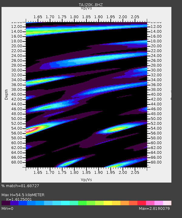
| Estimated Moho Depth: |
54.5 km |
| Estimated Crust Vp/Vs: |
1.61 |
| Assumed Crust Vp: |
6.566 km/s |
| Estimated Crust Vs: |
4.072 km/s |
| Estimated Crust Poisson's Ratio: |
0.19 |
|
| Radial Match: |
81.68727 % |
| Radial Bump: |
400 |
| Transverse Match: |
75.31951 % |
| Transverse Bump: |
400 |
| SOD ConfigId: |
24334971 |
| Insert Time: |
2021-05-12 02:37:30.188 +0000 |
| GWidth: |
2.5 |
| Max Bumps: |
400 |
| Tol: |
0.001 |
|

Signal To Noise
| Channel | StoN | STA | LTA |
| TA:I20K: :BHZ:20210428T02:32:34.549977Z | 17.123781 | 1.6765612E-6 | 9.7908355E-8 |
| TA:I20K: :BHN:20210428T02:32:34.549977Z | 0.98809516 | 6.346557E-7 | 6.4230215E-7 |
| TA:I20K: :BHE:20210428T02:32:34.549977Z | 2.9275448 | 1.0954427E-6 | 3.7418476E-7 |
| Arrivals |
| Ps | 5.3 SECOND |
| PpPs | 21 SECOND |
| PsPs/PpSs | 26 SECOND |


