You are here: Home > Network List > TA - USArray Transportable Network (new EarthScope stations) Stations List
> Station I30M Mount Dempster, Yukon, CAN > Earthquake Result Viewer
I30M Mount Dempster, Yukon, CAN - Earthquake Result Viewer
| Earthquake location: |
Northeastern India |
| Earthquake latitude/longitude: |
26.8/92.4 |
| Earthquake time(UTC): |
2021/04/28 (118) 02:21:25 GMT |
| Earthquake Depth: |
29 km |
| Earthquake Magnitude: |
6.0 mww |
| Earthquake Catalog/Contributor: |
NEIC PDE/us |
|
| Network: |
TA USArray Transportable Network (new EarthScope stations) |
| Station: |
I30M Mount Dempster, Yukon, CAN |
| Lat/Lon: |
65.22 N/136.38 W |
| Elevation: |
1399 m |
|
| Distance: |
80.9 deg |
| Az: |
18.731 deg |
| Baz: |
317.067 deg |
| Ray Param: |
0.04793599 |
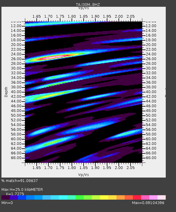
| Estimated Moho Depth: |
25.0 km |
| Estimated Crust Vp/Vs: |
1.73 |
| Assumed Crust Vp: |
6.566 km/s |
| Estimated Crust Vs: |
3.801 km/s |
| Estimated Crust Poisson's Ratio: |
0.25 |
|
| Radial Match: |
91.08637 % |
| Radial Bump: |
400 |
| Transverse Match: |
81.30509 % |
| Transverse Bump: |
400 |
| SOD ConfigId: |
24334971 |
| Insert Time: |
2021-05-12 02:37:34.280 +0000 |
| GWidth: |
2.5 |
| Max Bumps: |
400 |
| Tol: |
0.001 |
|
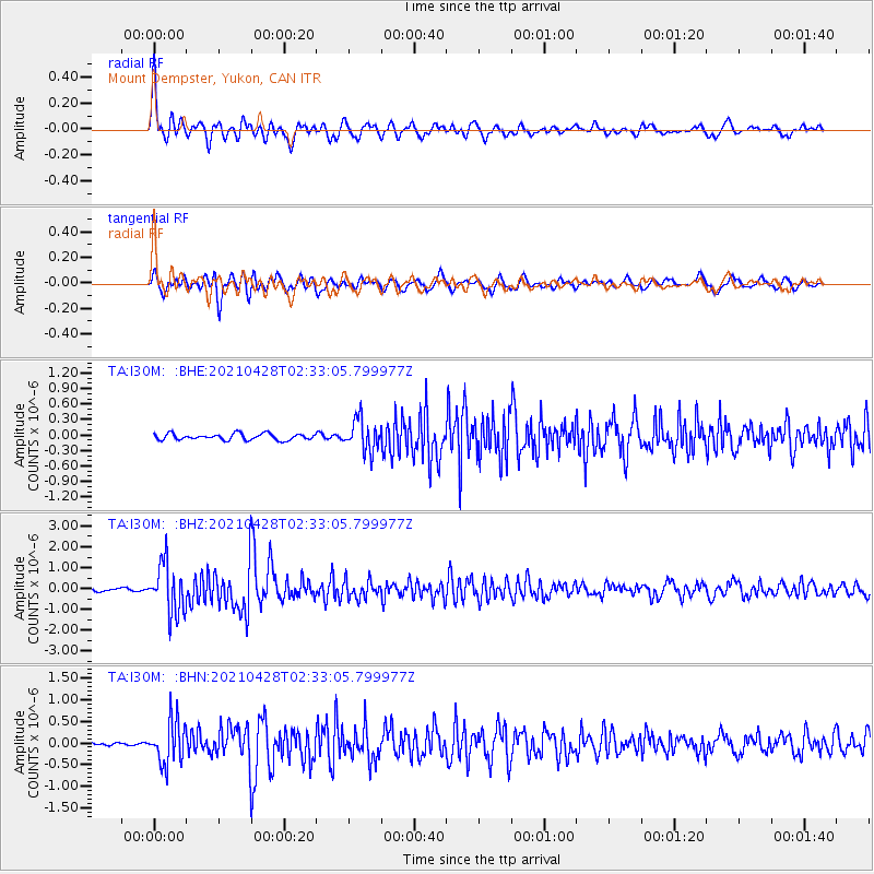
Signal To Noise
| Channel | StoN | STA | LTA |
| TA:I30M: :BHZ:20210428T02:33:05.799977Z | 23.116413 | 1.19166E-6 | 5.1550384E-8 |
| TA:I30M: :BHN:20210428T02:33:05.799977Z | 9.405698 | 5.033349E-7 | 5.351383E-8 |
| TA:I30M: :BHE:20210428T02:33:05.799977Z | 4.925027 | 3.0006768E-7 | 6.0927114E-8 |
| Arrivals |
| Ps | 2.9 SECOND |
| PpPs | 10 SECOND |
| PsPs/PpSs | 13 SECOND |


