You are here: Home > Network List > TA - USArray Transportable Network (new EarthScope stations) Stations List
> Station K17K Iditarod, AK, USA > Earthquake Result Viewer
K17K Iditarod, AK, USA - Earthquake Result Viewer
| Earthquake location: |
Northeastern India |
| Earthquake latitude/longitude: |
26.8/92.4 |
| Earthquake time(UTC): |
2021/04/28 (118) 02:21:25 GMT |
| Earthquake Depth: |
29 km |
| Earthquake Magnitude: |
6.0 mww |
| Earthquake Catalog/Contributor: |
NEIC PDE/us |
|
| Network: |
TA USArray Transportable Network (new EarthScope stations) |
| Station: |
K17K Iditarod, AK, USA |
| Lat/Lon: |
62.72 N/158.30 W |
| Elevation: |
339 m |
|
| Distance: |
74.8 deg |
| Az: |
26.79 deg |
| Baz: |
299.041 deg |
| Ray Param: |
0.052038733 |
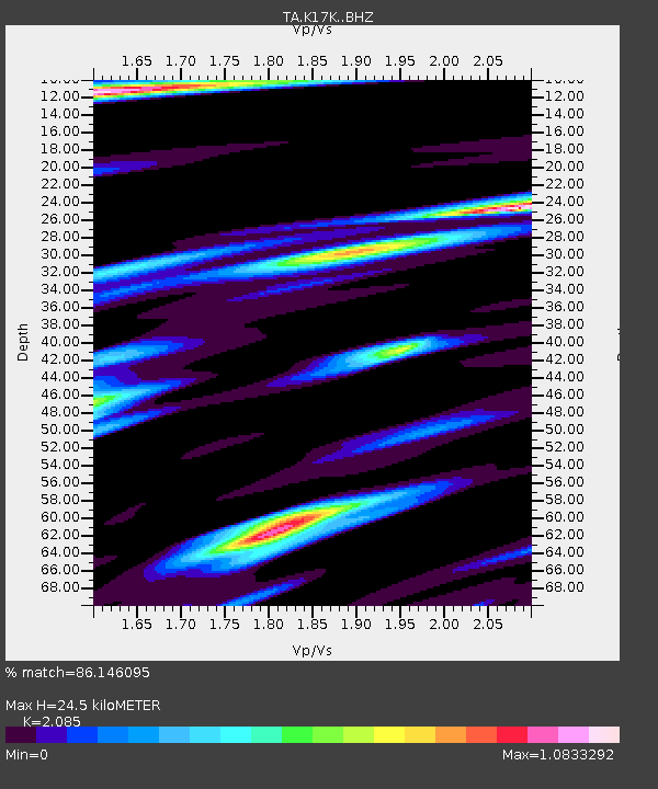
| Estimated Moho Depth: |
24.5 km |
| Estimated Crust Vp/Vs: |
2.09 |
| Assumed Crust Vp: |
6.276 km/s |
| Estimated Crust Vs: |
3.01 km/s |
| Estimated Crust Poisson's Ratio: |
0.35 |
|
| Radial Match: |
86.146095 % |
| Radial Bump: |
400 |
| Transverse Match: |
77.188995 % |
| Transverse Bump: |
400 |
| SOD ConfigId: |
24334971 |
| Insert Time: |
2021-05-12 02:37:43.002 +0000 |
| GWidth: |
2.5 |
| Max Bumps: |
400 |
| Tol: |
0.001 |
|

Signal To Noise
| Channel | StoN | STA | LTA |
| TA:K17K: :BHZ:20210428T02:32:32.174977Z | 10.154268 | 1.3872776E-6 | 1.3662016E-7 |
| TA:K17K: :BHN:20210428T02:32:32.174977Z | 2.4924762 | 3.2961876E-7 | 1.322455E-7 |
| TA:K17K: :BHE:20210428T02:32:32.174977Z | 1.9880924 | 4.3121702E-7 | 2.1689989E-7 |
| Arrivals |
| Ps | 4.3 SECOND |
| PpPs | 12 SECOND |
| PsPs/PpSs | 16 SECOND |


