You are here: Home > Network List > TA - USArray Transportable Network (new EarthScope stations) Stations List
> Station L27K Beaver Creek, Northway Junction, AK, USA > Earthquake Result Viewer
L27K Beaver Creek, Northway Junction, AK, USA - Earthquake Result Viewer

| Earthquake location: |
Northeastern India |
| Earthquake latitude/longitude: |
26.8/92.4 |
| Earthquake time(UTC): |
2021/04/28 (118) 02:21:25 GMT |
| Earthquake Depth: |
29 km |
| Earthquake Magnitude: |
6.0 mww |
| Earthquake Catalog/Contributor: |
NEIC PDE/us |
|
| Network: |
TA USArray Transportable Network (new EarthScope stations) |
| Station: |
L27K Beaver Creek, Northway Junction, AK, USA |
| Lat/Lon: |
63.06 N/141.83 W |
| Elevation: |
755 m |
|
| Distance: |
80.7 deg |
| Az: |
21.995 deg |
| Baz: |
312.688 deg |
| Ray Param: |
0.04804778 |
| Estimated Moho Depth: |
32.5 km |
| Estimated Crust Vp/Vs: |
1.69 |
| Assumed Crust Vp: |
6.566 km/s |
| Estimated Crust Vs: |
3.891 km/s |
| Estimated Crust Poisson's Ratio: |
0.23 |
|
| Radial Match: |
88.83233 % |
| Radial Bump: |
400 |
| Transverse Match: |
83.32006 % |
| Transverse Bump: |
400 |
| SOD ConfigId: |
24334971 |
| Insert Time: |
2021-05-12 02:37:46.701 +0000 |
| GWidth: |
2.5 |
| Max Bumps: |
400 |
| Tol: |
0.001 |
|
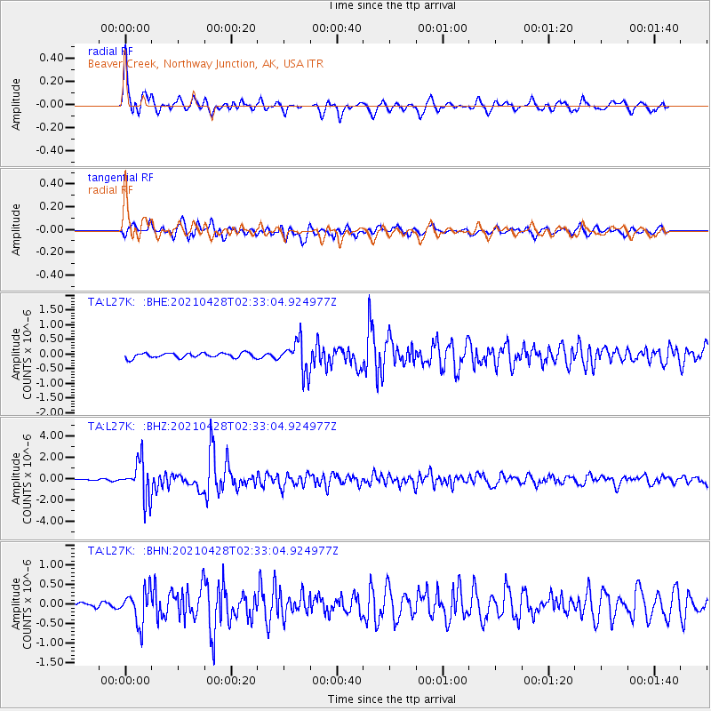
Signal To Noise
| Channel | StoN | STA | LTA |
| TA:L27K: :BHZ:20210428T02:33:04.924977Z | 26.302147 | 1.6918705E-6 | 6.4324425E-8 |
| TA:L27K: :BHN:20210428T02:33:04.924977Z | 5.329185 | 4.2281627E-7 | 7.933976E-8 |
| TA:L27K: :BHE:20210428T02:33:04.924977Z | 6.525216 | 5.364915E-7 | 8.221819E-8 |
| Arrivals |
| Ps | 3.5 SECOND |
| PpPs | 13 SECOND |
| PsPs/PpSs | 16 SECOND |


