You are here: Home > Network List > AZ - ANZA Regional Network Stations List
> Station KNW AZ.KNW > Earthquake Result Viewer
KNW AZ.KNW - Earthquake Result Viewer
| Earthquake location: |
Southern Argentina |
| Earthquake latitude/longitude: |
-37.3/-70.8 |
| Earthquake time(UTC): |
2021/04/29 (119) 02:17:16 GMT |
| Earthquake Depth: |
137 km |
| Earthquake Magnitude: |
5.7 Mww |
| Earthquake Catalog/Contributor: |
NEIC PDE/us |
|
| Network: |
AZ ANZA Regional Network |
| Station: |
KNW AZ.KNW |
| Lat/Lon: |
33.71 N/116.71 W |
| Elevation: |
1507 m |
|
| Distance: |
82.6 deg |
| Az: |
322.853 deg |
| Baz: |
144.694 deg |
| Ray Param: |
0.046493582 |
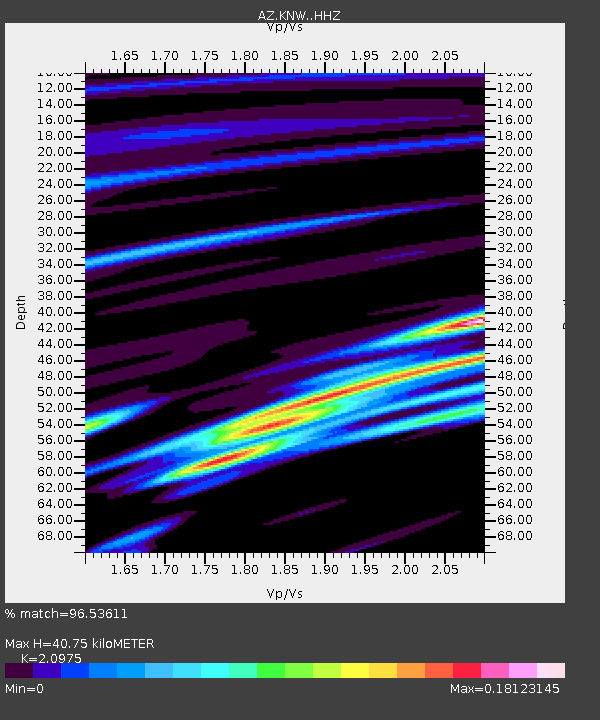
| Estimated Moho Depth: |
40.75 km |
| Estimated Crust Vp/Vs: |
2.10 |
| Assumed Crust Vp: |
6.264 km/s |
| Estimated Crust Vs: |
2.986 km/s |
| Estimated Crust Poisson's Ratio: |
0.35 |
|
| Radial Match: |
96.53611 % |
| Radial Bump: |
152 |
| Transverse Match: |
57.58964 % |
| Transverse Bump: |
400 |
| SOD ConfigId: |
24334971 |
| Insert Time: |
2021-05-13 02:19:33.786 +0000 |
| GWidth: |
2.5 |
| Max Bumps: |
400 |
| Tol: |
0.001 |
|

Signal To Noise
| Channel | StoN | STA | LTA |
| AZ:KNW: :HHZ:20210429T02:28:53.298012Z | 4.720185 | 2.5816234E-7 | 5.469327E-8 |
| AZ:KNW: :HHN:20210429T02:28:53.298012Z | 3.2967992 | 1.4179594E-7 | 4.3010182E-8 |
| AZ:KNW: :HHE:20210429T02:28:53.298012Z | 1.6073782 | 1.3356855E-7 | 8.309715E-8 |
| Arrivals |
| Ps | 7.3 SECOND |
| PpPs | 20 SECOND |
| PsPs/PpSs | 27 SECOND |


