You are here: Home > Network List > CI - Caltech Regional Seismic Network Stations List
> Station MPM Manuel Prospect Mine, California, USA > Earthquake Result Viewer
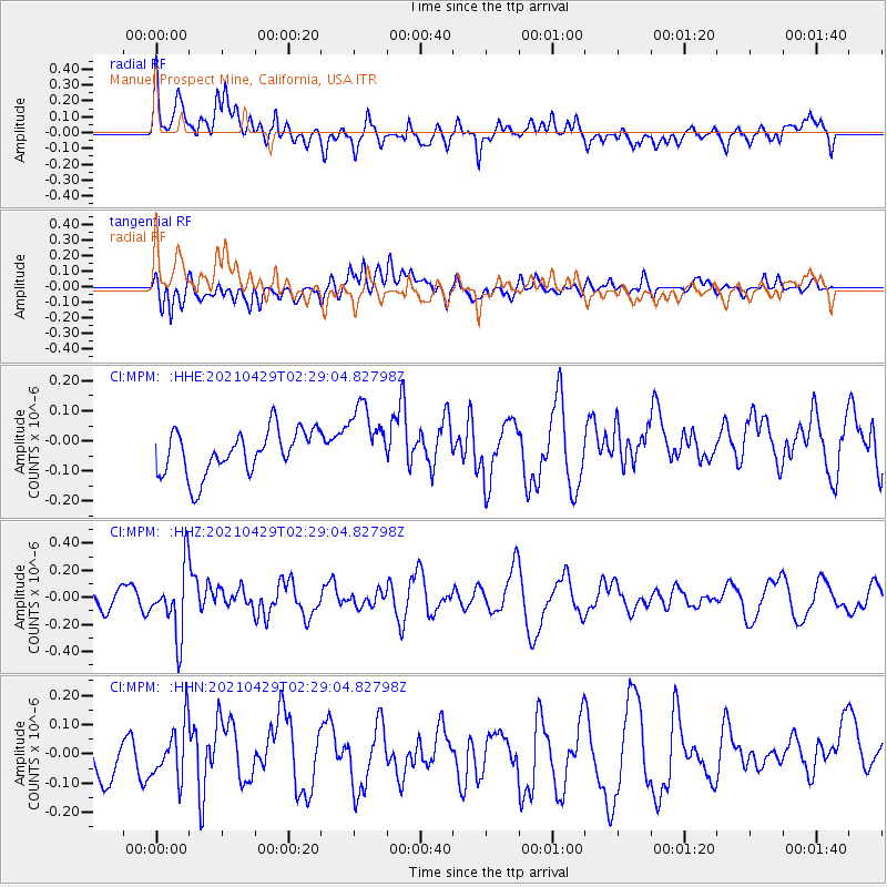
MPM Manuel Prospect Mine, California, USA - Earthquake Result Viewer
*The percent match for this event was below the threshold and hence no stack was calculated.
| Earthquake location: |
Southern Argentina |
| Earthquake latitude/longitude: |
-37.3/-70.8 |
| Earthquake time(UTC): |
2021/04/29 (119) 02:17:16 GMT |
| Earthquake Depth: |
137 km |
| Earthquake Magnitude: |
5.7 Mww |
| Earthquake Catalog/Contributor: |
NEIC PDE/us |
|
| Network: |
CI Caltech Regional Seismic Network |
| Station: |
MPM Manuel Prospect Mine, California, USA |
| Lat/Lon: |
36.06 N/117.49 W |
| Elevation: |
185 m |
|
| Distance: |
84.8 deg |
| Az: |
323.695 deg |
| Baz: |
144.344 deg |
| Ray Param: |
$rayparam |
*The percent match for this event was below the threshold and hence was not used in the summary stack. |
|
| Radial Match: |
43.574577 % |
| Radial Bump: |
400 |
| Transverse Match: |
58.04613 % |
| Transverse Bump: |
400 |
| SOD ConfigId: |
24334971 |
| Insert Time: |
2021-05-13 02:21:58.117 +0000 |
| GWidth: |
2.5 |
| Max Bumps: |
400 |
| Tol: |
0.001 |
|
Signal To Noise
| Channel | StoN | STA | LTA |
| CI:MPM: :HHZ:20210429T02:29:04.82798Z | 3.4075236 | 2.5002637E-7 | 7.337481E-8 |
| CI:MPM: :HHN:20210429T02:29:04.82798Z | 1.2897699 | 9.49342E-8 | 7.3605534E-8 |
| CI:MPM: :HHE:20210429T02:29:04.82798Z | 1.5823454 | 1.1615312E-7 | 7.340567E-8 |
| Arrivals |
| Ps | |
| PpPs | |
| PsPs/PpSs | |


