You are here: Home > Network List > O2 - Oklahoma Consolidated Temporary Seismic Networks Stations List
> Station SHWN Shawnee, Oklahoma, USA > Earthquake Result Viewer
SHWN Shawnee, Oklahoma, USA - Earthquake Result Viewer
| Earthquake location: |
Southern Argentina |
| Earthquake latitude/longitude: |
-37.3/-70.8 |
| Earthquake time(UTC): |
2021/04/29 (119) 02:17:16 GMT |
| Earthquake Depth: |
137 km |
| Earthquake Magnitude: |
5.7 Mww |
| Earthquake Catalog/Contributor: |
NEIC PDE/us |
|
| Network: |
O2 Oklahoma Consolidated Temporary Seismic Networks |
| Station: |
SHWN Shawnee, Oklahoma, USA |
| Lat/Lon: |
35.34 N/97.02 W |
| Elevation: |
320 m |
|
| Distance: |
76.2 deg |
| Az: |
338.161 deg |
| Baz: |
158.715 deg |
| Ray Param: |
0.050795883 |
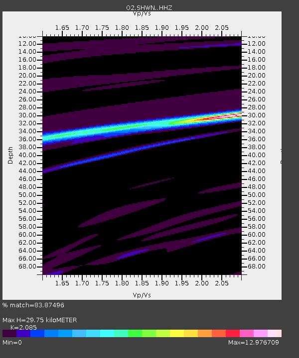
| Estimated Moho Depth: |
29.75 km |
| Estimated Crust Vp/Vs: |
2.09 |
| Assumed Crust Vp: |
6.426 km/s |
| Estimated Crust Vs: |
3.082 km/s |
| Estimated Crust Poisson's Ratio: |
0.35 |
|
| Radial Match: |
83.87496 % |
| Radial Bump: |
201 |
| Transverse Match: |
74.15367 % |
| Transverse Bump: |
195 |
| SOD ConfigId: |
24334971 |
| Insert Time: |
2021-05-13 02:32:04.832 +0000 |
| GWidth: |
2.5 |
| Max Bumps: |
400 |
| Tol: |
0.001 |
|

Signal To Noise
| Channel | StoN | STA | LTA |
| O2:SHWN: :HHZ:20210429T02:28:19.220009Z | 1.1668552 | 1.4862774E-6 | 1.2737462E-6 |
| O2:SHWN: :HHN:20210429T02:28:19.220009Z | 4.842602 | 1.36995895E-5 | 2.828973E-6 |
| O2:SHWN: :HHE:20210429T02:28:19.220009Z | 0.8653955 | 2.7527734E-5 | 3.1809428E-5 |
| Arrivals |
| Ps | 5.2 SECOND |
| PpPs | 14 SECOND |
| PsPs/PpSs | 19 SECOND |


