You are here: Home > Network List > US - United States National Seismic Network Stations List
> Station AGMN Agassiz National Wildlife Refuge, Minnesota, USA > Earthquake Result Viewer
AGMN Agassiz National Wildlife Refuge, Minnesota, USA - Earthquake Result Viewer
*The percent match for this event was below the threshold and hence no stack was calculated.
| Earthquake location: |
Southern Argentina |
| Earthquake latitude/longitude: |
-37.3/-70.8 |
| Earthquake time(UTC): |
2021/04/29 (119) 02:17:16 GMT |
| Earthquake Depth: |
137 km |
| Earthquake Magnitude: |
5.7 Mww |
| Earthquake Catalog/Contributor: |
NEIC PDE/us |
|
| Network: |
US United States National Seismic Network |
| Station: |
AGMN Agassiz National Wildlife Refuge, Minnesota, USA |
| Lat/Lon: |
48.30 N/95.86 W |
| Elevation: |
351 m |
|
| Distance: |
88.1 deg |
| Az: |
343.555 deg |
| Baz: |
160.232 deg |
| Ray Param: |
$rayparam |
*The percent match for this event was below the threshold and hence was not used in the summary stack. |
|
| Radial Match: |
50.008614 % |
| Radial Bump: |
400 |
| Transverse Match: |
63.92716 % |
| Transverse Bump: |
400 |
| SOD ConfigId: |
24334971 |
| Insert Time: |
2021-05-13 02:36:58.194 +0000 |
| GWidth: |
2.5 |
| Max Bumps: |
400 |
| Tol: |
0.001 |
|
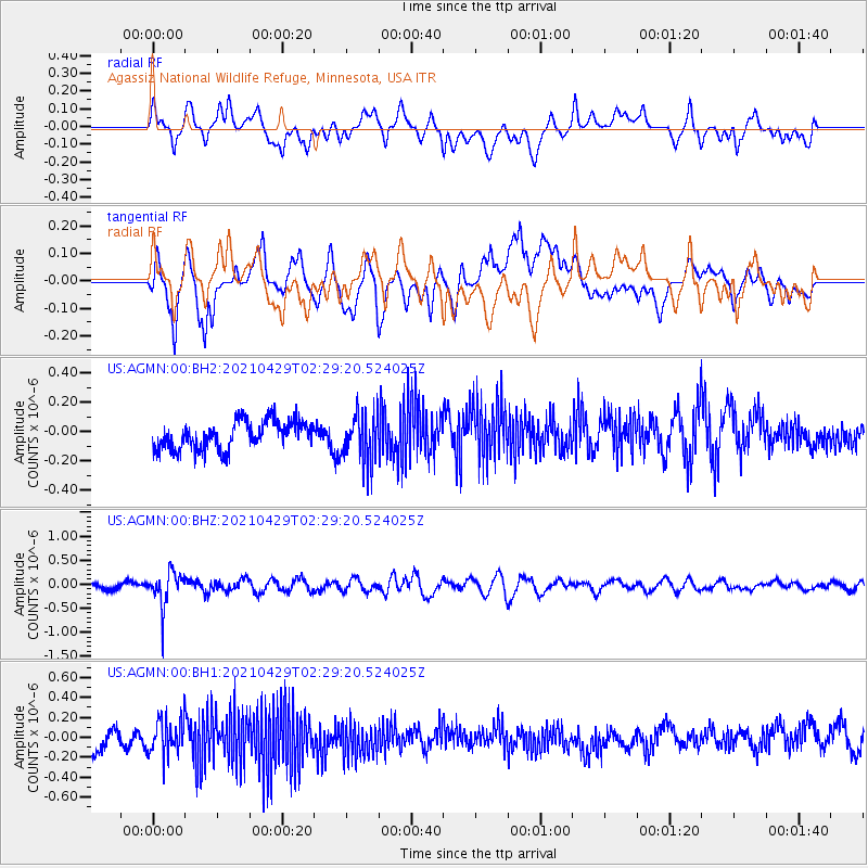
Signal To Noise
| Channel | StoN | STA | LTA |
| US:AGMN:00:BHZ:20210429T02:29:20.524025Z | 3.2740583 | 3.5672494E-7 | 1.0895497E-7 |
| US:AGMN:00:BH1:20210429T02:29:20.524025Z | 1.4799632 | 1.7823479E-7 | 1.2043189E-7 |
| US:AGMN:00:BH2:20210429T02:29:20.524025Z | 1.811809 | 1.7158091E-7 | 9.4701434E-8 |
| Arrivals |
| Ps | |
| PpPs | |
| PsPs/PpSs | |


