You are here: Home > Network List > US - United States National Seismic Network Stations List
> Station DGMT Dagmar, Montana, USA > Earthquake Result Viewer
DGMT Dagmar, Montana, USA - Earthquake Result Viewer
*The percent match for this event was below the threshold and hence no stack was calculated.
| Earthquake location: |
Southern Argentina |
| Earthquake latitude/longitude: |
-37.3/-70.8 |
| Earthquake time(UTC): |
2021/04/29 (119) 02:17:16 GMT |
| Earthquake Depth: |
137 km |
| Earthquake Magnitude: |
5.7 Mww |
| Earthquake Catalog/Contributor: |
NEIC PDE/us |
|
| Network: |
US United States National Seismic Network |
| Station: |
DGMT Dagmar, Montana, USA |
| Lat/Lon: |
48.47 N/104.20 W |
| Elevation: |
0.0 m |
|
| Distance: |
90.4 deg |
| Az: |
338.507 deg |
| Baz: |
153.947 deg |
| Ray Param: |
$rayparam |
*The percent match for this event was below the threshold and hence was not used in the summary stack. |
|
| Radial Match: |
65.835236 % |
| Radial Bump: |
386 |
| Transverse Match: |
73.88781 % |
| Transverse Bump: |
308 |
| SOD ConfigId: |
24334971 |
| Insert Time: |
2021-05-13 02:37:09.867 +0000 |
| GWidth: |
2.5 |
| Max Bumps: |
400 |
| Tol: |
0.001 |
|
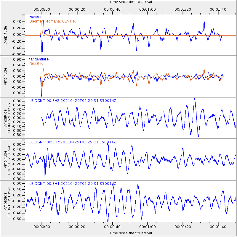
Signal To Noise
| Channel | StoN | STA | LTA |
| US:DGMT:00:BHZ:20210429T02:29:31.350014Z | 1.8629664 | 2.492795E-7 | 1.3380784E-7 |
| US:DGMT:00:BH1:20210429T02:29:31.350014Z | 0.907277 | 1.8577936E-7 | 2.0476587E-7 |
| US:DGMT:00:BH2:20210429T02:29:31.350014Z | 0.7855593 | 2.0382615E-7 | 2.5946628E-7 |
| Arrivals |
| Ps | |
| PpPs | |
| PsPs/PpSs | |


