You are here: Home > Network List > US - United States National Seismic Network Stations List
> Station GLMI Grayling, Michigan, USA > Earthquake Result Viewer
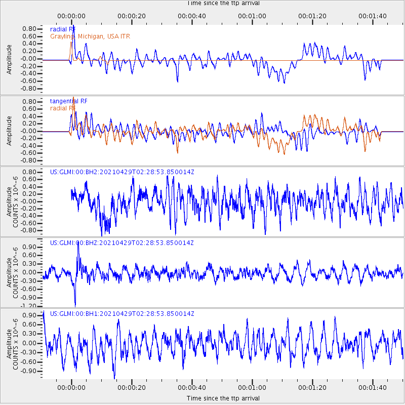
GLMI Grayling, Michigan, USA - Earthquake Result Viewer
*The percent match for this event was below the threshold and hence no stack was calculated.
| Earthquake location: |
Southern Argentina |
| Earthquake latitude/longitude: |
-37.3/-70.8 |
| Earthquake time(UTC): |
2021/04/29 (119) 02:17:16 GMT |
| Earthquake Depth: |
137 km |
| Earthquake Magnitude: |
5.7 Mww |
| Earthquake Catalog/Contributor: |
NEIC PDE/us |
|
| Network: |
US United States National Seismic Network |
| Station: |
GLMI Grayling, Michigan, USA |
| Lat/Lon: |
44.82 N/84.62 W |
| Elevation: |
387 m |
|
| Distance: |
82.7 deg |
| Az: |
350.128 deg |
| Baz: |
168.919 deg |
| Ray Param: |
$rayparam |
*The percent match for this event was below the threshold and hence was not used in the summary stack. |
|
| Radial Match: |
35.018215 % |
| Radial Bump: |
400 |
| Transverse Match: |
49.169495 % |
| Transverse Bump: |
400 |
| SOD ConfigId: |
24334971 |
| Insert Time: |
2021-05-13 02:37:18.551 +0000 |
| GWidth: |
2.5 |
| Max Bumps: |
400 |
| Tol: |
0.001 |
|
Signal To Noise
| Channel | StoN | STA | LTA |
| US:GLMI:00:BHZ:20210429T02:28:53.850014Z | 2.7409337 | 4.4664847E-7 | 1.6295486E-7 |
| US:GLMI:00:BH1:20210429T02:28:53.850014Z | 0.86054605 | 4.328125E-7 | 5.0295097E-7 |
| US:GLMI:00:BH2:20210429T02:28:53.850014Z | 1.2508007 | 4.1194292E-7 | 3.2934338E-7 |
| Arrivals |
| Ps | |
| PpPs | |
| PsPs/PpSs | |


