You are here: Home > Network List > GS - US Geological Survey Networks Stations List
> Station DEC08 Union Local 159 Surface Site > Earthquake Result Viewer
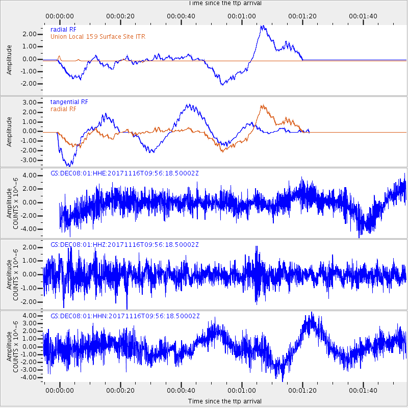
DEC08 Union Local 159 Surface Site - Earthquake Result Viewer
*The percent match for this event was below the threshold and hence no stack was calculated.
| Earthquake location: |
Southeast Of Honshu, Japan |
| Earthquake latitude/longitude: |
32.2/140.5 |
| Earthquake time(UTC): |
2017/11/16 (320) 09:43:35 GMT |
| Earthquake Depth: |
71 km |
| Earthquake Magnitude: |
5.8 Mww |
| Earthquake Catalog/Contributor: |
NEIC PDE/us |
|
| Network: |
GS US Geological Survey Networks |
| Station: |
DEC08 Union Local 159 Surface Site |
| Lat/Lon: |
39.86 N/88.92 W |
| Elevation: |
210 m |
|
| Distance: |
94.9 deg |
| Az: |
35.959 deg |
| Baz: |
319.693 deg |
| Ray Param: |
$rayparam |
*The percent match for this event was below the threshold and hence was not used in the summary stack. |
|
| Radial Match: |
65.541046 % |
| Radial Bump: |
400 |
| Transverse Match: |
60.84948 % |
| Transverse Bump: |
400 |
| SOD ConfigId: |
2429771 |
| Insert Time: |
2017-11-30 09:44:44.014 +0000 |
| GWidth: |
2.5 |
| Max Bumps: |
400 |
| Tol: |
0.001 |
|
Signal To Noise
| Channel | StoN | STA | LTA |
| GS:DEC08:01:HHZ:20171116T09:56:18.50002Z | 1.1049999 | 9.2293226E-7 | 8.352329E-7 |
| GS:DEC08:01:HHN:20171116T09:56:18.50002Z | 1.1006769 | 1.5856267E-6 | 1.4405924E-6 |
| GS:DEC08:01:HHE:20171116T09:56:18.50002Z | 0.818879 | 1.2666464E-6 | 1.5468055E-6 |
| Arrivals |
| Ps | |
| PpPs | |
| PsPs/PpSs | |


