You are here: Home > Network List > AV - Alaska Volcano Observatory Stations List
> Station MAPS Pakushin Southeast, Makushin Volcano, Alaska > Earthquake Result Viewer
MAPS Pakushin Southeast, Makushin Volcano, Alaska - Earthquake Result Viewer
| Earthquake location: |
Off E. Coast Of N. Island, N.Z. |
| Earthquake latitude/longitude: |
-37.6/179.4 |
| Earthquake time(UTC): |
2021/04/29 (119) 03:58:48 GMT |
| Earthquake Depth: |
23 km |
| Earthquake Magnitude: |
5.8 Mww |
| Earthquake Catalog/Contributor: |
NEIC PDE/us |
|
| Network: |
AV Alaska Volcano Observatory |
| Station: |
MAPS Pakushin Southeast, Makushin Volcano, Alaska |
| Lat/Lon: |
53.81 N/166.94 W |
| Elevation: |
333 m |
|
| Distance: |
91.8 deg |
| Az: |
8.043 deg |
| Baz: |
190.801 deg |
| Ray Param: |
0.041554693 |
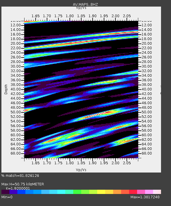
| Estimated Moho Depth: |
50.75 km |
| Estimated Crust Vp/Vs: |
1.92 |
| Assumed Crust Vp: |
3.943 km/s |
| Estimated Crust Vs: |
2.054 km/s |
| Estimated Crust Poisson's Ratio: |
0.31 |
|
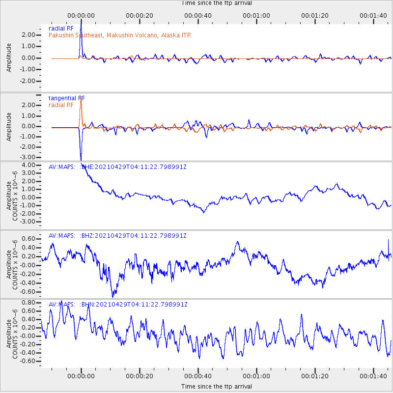
| Radial Match: |
81.826126 % |
| Radial Bump: |
400 |
| Transverse Match: |
62.488247 % |
| Transverse Bump: |
351 |
| SOD ConfigId: |
24334971 |
| Insert Time: |
2021-05-13 04:01:39.446 +0000 |
| GWidth: |
2.5 |
| Max Bumps: |
400 |
| Tol: |
0.001 |
|
Signal To Noise
| Channel | StoN | STA | LTA |
| AV:MAPS: :BHZ:20210429T04:11:22.798991Z | 1.2191998 | 5.46999E-7 | 4.486541E-7 |
| AV:MAPS: :BHN:20210429T04:11:22.798991Z | 0.93830794 | 1.4130627E-6 | 1.505969E-6 |
| AV:MAPS: :BHE:20210429T04:11:22.798991Z | 1.2411604 | 1.3631529E-6 | 1.0982892E-6 |
| Arrivals |
| Ps | 12 SECOND |
| PpPs | 37 SECOND |
| PsPs/PpSs | 49 SECOND |


