You are here: Home > Network List > GS - US Geological Survey Networks Stations List
> Station OK051 E0350 and S34600 Roads, Ralston, OK > Earthquake Result Viewer
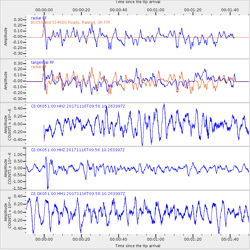
OK051 E0350 and S34600 Roads, Ralston, OK - Earthquake Result Viewer
*The percent match for this event was below the threshold and hence no stack was calculated.
| Earthquake location: |
Southeast Of Honshu, Japan |
| Earthquake latitude/longitude: |
32.2/140.5 |
| Earthquake time(UTC): |
2017/11/16 (320) 09:43:35 GMT |
| Earthquake Depth: |
71 km |
| Earthquake Magnitude: |
5.8 Mww |
| Earthquake Catalog/Contributor: |
NEIC PDE/us |
|
| Network: |
GS US Geological Survey Networks |
| Station: |
OK051 E0350 and S34600 Roads, Ralston, OK |
| Lat/Lon: |
36.51 N/96.84 W |
| Elevation: |
263 m |
|
| Distance: |
93.1 deg |
| Az: |
42.816 deg |
| Baz: |
314.336 deg |
| Ray Param: |
$rayparam |
*The percent match for this event was below the threshold and hence was not used in the summary stack. |
|
| Radial Match: |
61.70789 % |
| Radial Bump: |
400 |
| Transverse Match: |
51.75361 % |
| Transverse Bump: |
400 |
| SOD ConfigId: |
2429771 |
| Insert Time: |
2017-11-30 09:45:12.337 +0000 |
| GWidth: |
2.5 |
| Max Bumps: |
400 |
| Tol: |
0.001 |
|
Signal To Noise
| Channel | StoN | STA | LTA |
| GS:OK051:00:HHZ:20171116T09:56:10.263997Z | 3.9803195 | 6.397918E-7 | 1.6073881E-7 |
| GS:OK051:00:HH1:20171116T09:56:10.263997Z | 0.94681317 | 2.4023208E-7 | 2.5372702E-7 |
| GS:OK051:00:HH2:20171116T09:56:10.263997Z | 1.6669098 | 2.1605298E-7 | 1.2961287E-7 |
| Arrivals |
| Ps | |
| PpPs | |
| PsPs/PpSs | |


