You are here: Home > Network List > IU - Global Seismograph Network (GSN - IRIS/USGS) Stations List
> Station RSSD Black Hills, South Dakota, USA > Earthquake Result Viewer
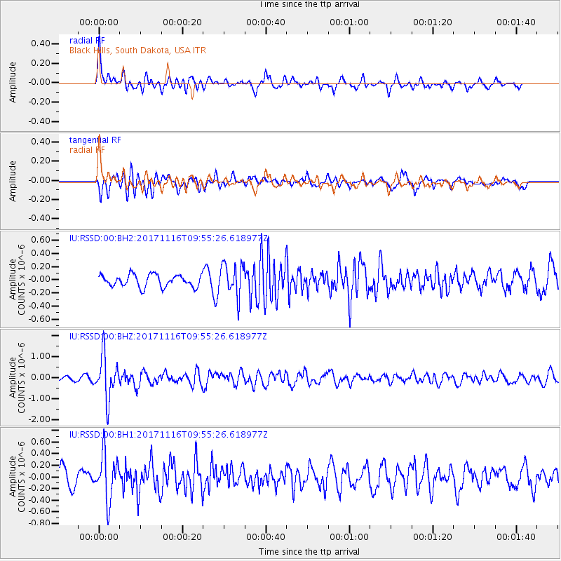
RSSD Black Hills, South Dakota, USA - Earthquake Result Viewer
*The percent match for this event was below the threshold and hence no stack was calculated.
| Earthquake location: |
Southeast Of Honshu, Japan |
| Earthquake latitude/longitude: |
32.2/140.5 |
| Earthquake time(UTC): |
2017/11/16 (320) 09:43:35 GMT |
| Earthquake Depth: |
71 km |
| Earthquake Magnitude: |
5.8 Mww |
| Earthquake Catalog/Contributor: |
NEIC PDE/us |
|
| Network: |
IU Global Seismograph Network (GSN - IRIS/USGS) |
| Station: |
RSSD Black Hills, South Dakota, USA |
| Lat/Lon: |
44.12 N/104.04 W |
| Elevation: |
2090 m |
|
| Distance: |
83.9 deg |
| Az: |
40.855 deg |
| Baz: |
309.631 deg |
| Ray Param: |
$rayparam |
*The percent match for this event was below the threshold and hence was not used in the summary stack. |
|
| Radial Match: |
66.091774 % |
| Radial Bump: |
400 |
| Transverse Match: |
73.45384 % |
| Transverse Bump: |
400 |
| SOD ConfigId: |
2429771 |
| Insert Time: |
2017-11-30 09:45:51.108 +0000 |
| GWidth: |
2.5 |
| Max Bumps: |
400 |
| Tol: |
0.001 |
|
Signal To Noise
| Channel | StoN | STA | LTA |
| IU:RSSD:00:BHZ:20171116T09:55:26.618977Z | 10.879659 | 1.024948E-6 | 9.420774E-8 |
| IU:RSSD:00:BH1:20171116T09:55:26.618977Z | 2.4268515 | 4.018818E-7 | 1.6559801E-7 |
| IU:RSSD:00:BH2:20171116T09:55:26.618977Z | 2.6847713 | 2.449005E-7 | 9.1218375E-8 |
| Arrivals |
| Ps | |
| PpPs | |
| PsPs/PpSs | |


