You are here: Home > Network List > IW - Intermountain West Stations List
> Station MOOW Moose Ponds, Wyoming, USA > Earthquake Result Viewer
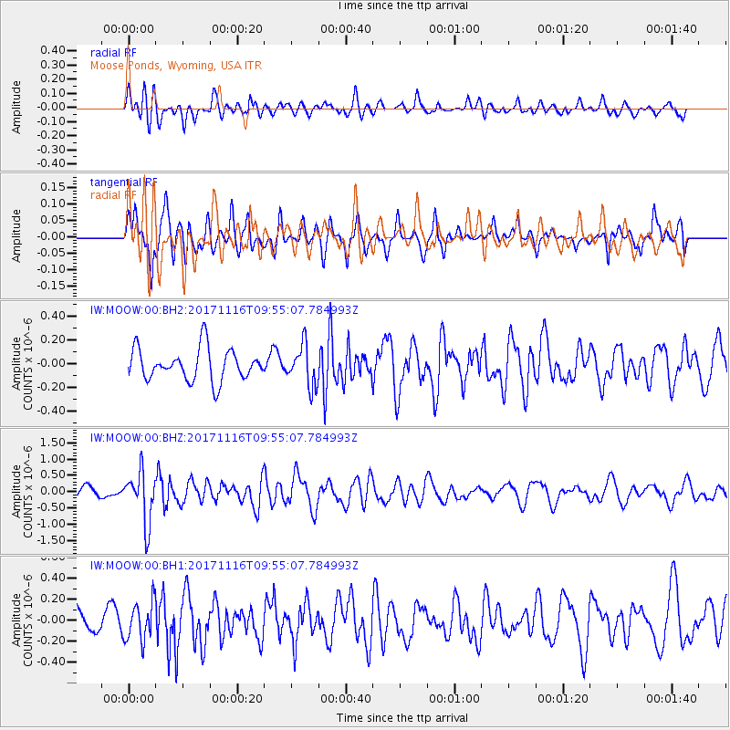
MOOW Moose Ponds, Wyoming, USA - Earthquake Result Viewer
*The percent match for this event was below the threshold and hence no stack was calculated.
| Earthquake location: |
Southeast Of Honshu, Japan |
| Earthquake latitude/longitude: |
32.2/140.5 |
| Earthquake time(UTC): |
2017/11/16 (320) 09:43:35 GMT |
| Earthquake Depth: |
71 km |
| Earthquake Magnitude: |
5.8 Mww |
| Earthquake Catalog/Contributor: |
NEIC PDE/us |
|
| Network: |
IW Intermountain West |
| Station: |
MOOW Moose Ponds, Wyoming, USA |
| Lat/Lon: |
43.75 N/110.74 W |
| Elevation: |
2128 m |
|
| Distance: |
80.3 deg |
| Az: |
44.133 deg |
| Baz: |
305.439 deg |
| Ray Param: |
$rayparam |
*The percent match for this event was below the threshold and hence was not used in the summary stack. |
|
| Radial Match: |
56.946995 % |
| Radial Bump: |
400 |
| Transverse Match: |
61.270355 % |
| Transverse Bump: |
376 |
| SOD ConfigId: |
2429771 |
| Insert Time: |
2017-11-30 09:46:06.536 +0000 |
| GWidth: |
2.5 |
| Max Bumps: |
400 |
| Tol: |
0.001 |
|
Signal To Noise
| Channel | StoN | STA | LTA |
| IW:MOOW:00:BHZ:20171116T09:55:07.784993Z | 5.417289 | 7.9374337E-7 | 1.4652042E-7 |
| IW:MOOW:00:BH1:20171116T09:55:07.784993Z | 1.9111642 | 1.8301787E-7 | 9.576251E-8 |
| IW:MOOW:00:BH2:20171116T09:55:07.784993Z | 1.2957746 | 1.7245844E-7 | 1.3309294E-7 |
| Arrivals |
| Ps | |
| PpPs | |
| PsPs/PpSs | |


