You are here: Home > Network List > TX - Texas Seismological Network Stations List
> Station WTFS Witchita Falls > Earthquake Result Viewer
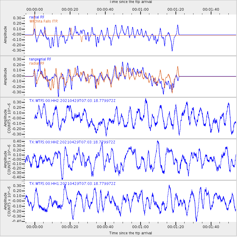
WTFS Witchita Falls - Earthquake Result Viewer
*The percent match for this event was below the threshold and hence no stack was calculated.
| Earthquake location: |
Kermadec Islands Region |
| Earthquake latitude/longitude: |
-29.6/-175.5 |
| Earthquake time(UTC): |
2021/04/29 (119) 06:50:22 GMT |
| Earthquake Depth: |
10 km |
| Earthquake Magnitude: |
5.9 mww |
| Earthquake Catalog/Contributor: |
NEIC PDE/us |
|
| Network: |
TX Texas Seismological Network |
| Station: |
WTFS Witchita Falls |
| Lat/Lon: |
33.77 N/98.46 W |
| Elevation: |
277 m |
|
| Distance: |
96.2 deg |
| Az: |
54.738 deg |
| Baz: |
238.653 deg |
| Ray Param: |
$rayparam |
*The percent match for this event was below the threshold and hence was not used in the summary stack. |
|
| Radial Match: |
54.043335 % |
| Radial Bump: |
400 |
| Transverse Match: |
48.255566 % |
| Transverse Bump: |
400 |
| SOD ConfigId: |
24334971 |
| Insert Time: |
2021-05-13 07:04:08.836 +0000 |
| GWidth: |
2.5 |
| Max Bumps: |
400 |
| Tol: |
0.001 |
|
Signal To Noise
| Channel | StoN | STA | LTA |
| TX:WTFS:00:HHZ:20210429T07:03:18.779972Z | 1.2741778 | 8.9813746E-8 | 7.0487616E-8 |
| TX:WTFS:00:HH1:20210429T07:03:18.779972Z | 1.2303286 | 1.4211138E-7 | 1.1550684E-7 |
| TX:WTFS:00:HH2:20210429T07:03:18.779972Z | 1.2875245 | 1.6144848E-7 | 1.253945E-7 |
| Arrivals |
| Ps | |
| PpPs | |
| PsPs/PpSs | |


