You are here: Home > Network List > S1 - Australian Seismometers in Schools Stations List
> Station AUMBR Murray Bridge High School > Earthquake Result Viewer
AUMBR Murray Bridge High School - Earthquake Result Viewer
| Earthquake location: |
Kermadec Islands Region |
| Earthquake latitude/longitude: |
-29.4/-176.4 |
| Earthquake time(UTC): |
2021/04/29 (119) 06:50:27 GMT |
| Earthquake Depth: |
10 km |
| Earthquake Magnitude: |
6.1 mww |
| Earthquake Catalog/Contributor: |
NEIC PDE/us |
|
| Network: |
S1 Australian Seismometers in Schools |
| Station: |
AUMBR Murray Bridge High School |
| Lat/Lon: |
35.13 S/139.29 E |
| Elevation: |
50 m |
|
| Distance: |
37.6 deg |
| Az: |
249.558 deg |
| Baz: |
93.977 deg |
| Ray Param: |
0.07603302 |
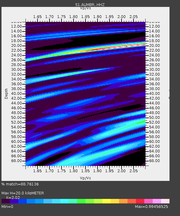
| Estimated Moho Depth: |
20.0 km |
| Estimated Crust Vp/Vs: |
2.02 |
| Assumed Crust Vp: |
6.576 km/s |
| Estimated Crust Vs: |
3.256 km/s |
| Estimated Crust Poisson's Ratio: |
0.34 |
|
| Radial Match: |
88.76136 % |
| Radial Bump: |
338 |
| Transverse Match: |
69.73182 % |
| Transverse Bump: |
400 |
| SOD ConfigId: |
24334971 |
| Insert Time: |
2021-05-13 07:16:50.699 +0000 |
| GWidth: |
2.5 |
| Max Bumps: |
400 |
| Tol: |
0.001 |
|

Signal To Noise
| Channel | StoN | STA | LTA |
| S1:AUMBR: :HHZ:20210429T06:57:11.849985Z | 6.8944917 | 1.5190652E-6 | 2.2033028E-7 |
| S1:AUMBR: :HHN:20210429T06:57:11.849985Z | 0.41029426 | 1.5006373E-7 | 3.657466E-7 |
| S1:AUMBR: :HHE:20210429T06:57:11.849985Z | 3.6173944 | 9.568862E-7 | 2.6452358E-7 |
| Arrivals |
| Ps | 3.3 SECOND |
| PpPs | 8.6 SECOND |
| PsPs/PpSs | 12 SECOND |


