You are here: Home > Network List > LB - Leo Brady Network Stations List
> Station DAC Darwin, Inyo County, California, USA > Earthquake Result Viewer
DAC Darwin, Inyo County, California, USA - Earthquake Result Viewer
| Earthquake location: |
Southern Bolivia |
| Earthquake latitude/longitude: |
-19.5/-66.3 |
| Earthquake time(UTC): |
2001/06/29 (180) 18:35:51 GMT |
| Earthquake Depth: |
274 km |
| Earthquake Magnitude: |
5.7 MB, 6.1 MW, 6.1 MW |
| Earthquake Catalog/Contributor: |
WHDF/NEIC |
|
| Network: |
LB Leo Brady Network |
| Station: |
DAC Darwin, Inyo County, California, USA |
| Lat/Lon: |
36.28 N/117.59 W |
| Elevation: |
1813 m |
|
| Distance: |
73.7 deg |
| Az: |
318.901 deg |
| Baz: |
129.887 deg |
| Ray Param: |
0.052048184 |
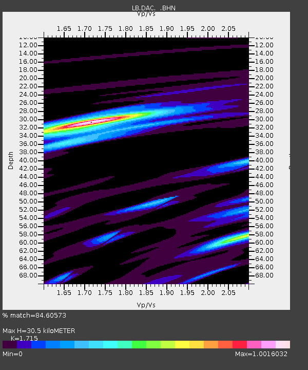
| Estimated Moho Depth: |
30.5 km |
| Estimated Crust Vp/Vs: |
1.72 |
| Assumed Crust Vp: |
6.279 km/s |
| Estimated Crust Vs: |
3.661 km/s |
| Estimated Crust Poisson's Ratio: |
0.24 |
|
| Radial Match: |
84.60573 % |
| Radial Bump: |
400 |
| Transverse Match: |
78.88256 % |
| Transverse Bump: |
400 |
| SOD ConfigId: |
20082 |
| Insert Time: |
2010-03-09 07:50:11.388 +0000 |
| GWidth: |
2.5 |
| Max Bumps: |
400 |
| Tol: |
0.001 |
|

Signal To Noise
| Channel | StoN | STA | LTA |
| LB:DAC: :BHN:20010629T18:46:25.058003Z | 5.411675 | 2.8167722E-7 | 5.2049916E-8 |
| LB:DAC: :BHE:20010629T18:46:25.060017Z | 6.032929 | 5.1622305E-7 | 8.5567564E-8 |
| LB:DAC: :BHZ:20010629T18:46:25.058003Z | 14.662212 | 1.310615E-6 | 8.938726E-8 |
| Arrivals |
| Ps | 3.6 SECOND |
| PpPs | 13 SECOND |
| PsPs/PpSs | 16 SECOND |


