You are here: Home > Network List > LB - Leo Brady Network Stations List
> Station DAC Darwin, Inyo County, California, USA > Earthquake Result Viewer
DAC Darwin, Inyo County, California, USA - Earthquake Result Viewer
| Earthquake location: |
Andreanof Islands, Aleutian Is. |
| Earthquake latitude/longitude: |
51.2/-179.8 |
| Earthquake time(UTC): |
2001/06/14 (165) 19:48:47 GMT |
| Earthquake Depth: |
18 km |
| Earthquake Magnitude: |
6.0 MB, 6.3 MS, 6.5 MW, 6.1 ML |
| Earthquake Catalog/Contributor: |
WHDF/NEIC |
|
| Network: |
LB Leo Brady Network |
| Station: |
DAC Darwin, Inyo County, California, USA |
| Lat/Lon: |
36.28 N/117.59 W |
| Elevation: |
1813 m |
|
| Distance: |
46.0 deg |
| Az: |
83.732 deg |
| Baz: |
309.229 deg |
| Ray Param: |
0.070896685 |
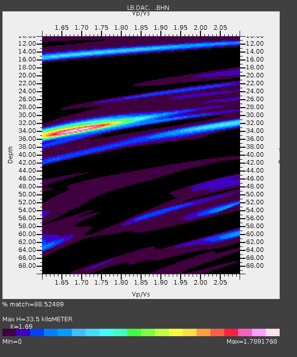
| Estimated Moho Depth: |
33.5 km |
| Estimated Crust Vp/Vs: |
1.69 |
| Assumed Crust Vp: |
6.279 km/s |
| Estimated Crust Vs: |
3.715 km/s |
| Estimated Crust Poisson's Ratio: |
0.23 |
|
| Radial Match: |
88.52489 % |
| Radial Bump: |
400 |
| Transverse Match: |
83.85863 % |
| Transverse Bump: |
400 |
| SOD ConfigId: |
20082 |
| Insert Time: |
2010-03-09 07:50:15.459 +0000 |
| GWidth: |
2.5 |
| Max Bumps: |
400 |
| Tol: |
0.001 |
|

Signal To Noise
| Channel | StoN | STA | LTA |
| LB:DAC: :BHN:20010614T19:56:39.140009Z | 2.5489783 | 1.1927717E-7 | 4.679411E-8 |
| LB:DAC: :BHE:20010614T19:56:39.140009Z | 2.7777727 | 1.3261123E-7 | 4.7740134E-8 |
| LB:DAC: :BHZ:20010614T19:56:39.140009Z | 2.3825433 | 3.2276492E-7 | 1.3547074E-7 |
| Arrivals |
| Ps | 3.9 SECOND |
| PpPs | 13 SECOND |
| PsPs/PpSs | 17 SECOND |


