You are here: Home > Network List > NN - Western Great Basin/Eastern Sierra Nevada Stations List
> Station ZPR Zephyr Cove, Lake Tahoe, Nevada > Earthquake Result Viewer
ZPR Zephyr Cove, Lake Tahoe, Nevada - Earthquake Result Viewer
| Earthquake location: |
Kermadec Islands Region |
| Earthquake latitude/longitude: |
-29.1/-177.0 |
| Earthquake time(UTC): |
2021/04/29 (119) 06:53:52 GMT |
| Earthquake Depth: |
10 km |
| Earthquake Magnitude: |
5.5 mb |
| Earthquake Catalog/Contributor: |
NEIC PDE/us |
|
| Network: |
NN Western Great Basin/Eastern Sierra Nevada |
| Station: |
ZPR Zephyr Cove, Lake Tahoe, Nevada |
| Lat/Lon: |
39.01 N/119.94 W |
| Elevation: |
2001 m |
|
| Distance: |
86.1 deg |
| Az: |
40.942 deg |
| Baz: |
227.418 deg |
| Ray Param: |
0.044288505 |
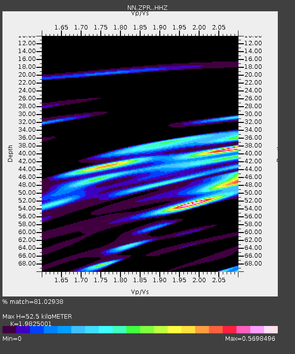
| Estimated Moho Depth: |
52.5 km |
| Estimated Crust Vp/Vs: |
1.98 |
| Assumed Crust Vp: |
6.279 km/s |
| Estimated Crust Vs: |
3.167 km/s |
| Estimated Crust Poisson's Ratio: |
0.33 |
|
| Radial Match: |
81.02938 % |
| Radial Bump: |
294 |
| Transverse Match: |
94.88322 % |
| Transverse Bump: |
157 |
| SOD ConfigId: |
24334971 |
| Insert Time: |
2021-05-13 07:28:29.994 +0000 |
| GWidth: |
2.5 |
| Max Bumps: |
400 |
| Tol: |
0.001 |
|

Signal To Noise
| Channel | StoN | STA | LTA |
| NN:ZPR: :HHZ:20210429T07:06:01.967986Z | 1.3094448 | 1.6883752E-7 | 1.2893825E-7 |
| NN:ZPR: :HHN:20210429T07:06:01.967986Z | 1.2417004 | 2.1732924E-7 | 1.7502552E-7 |
| NN:ZPR: :HHE:20210429T07:06:01.967986Z | 1.1149489 | 1.1539323E-7 | 1.03496426E-7 |
| Arrivals |
| Ps | 8.4 SECOND |
| PpPs | 24 SECOND |
| PsPs/PpSs | 33 SECOND |


