You are here: Home > Network List > LB - Leo Brady Network Stations List
> Station DAC Darwin, Inyo County, California, USA > Earthquake Result Viewer
DAC Darwin, Inyo County, California, USA - Earthquake Result Viewer
| Earthquake location: |
Near S. Coast Of Honshu, Japan |
| Earthquake latitude/longitude: |
33.2/137.1 |
| Earthquake time(UTC): |
2004/09/05 (249) 14:57:18 GMT |
| Earthquake Depth: |
10 km |
| Earthquake Magnitude: |
6.2 MB, 7.1 MS, 7.4 MW, 7.4 MW |
| Earthquake Catalog/Contributor: |
WHDF/NEIC |
|
| Network: |
LB Leo Brady Network |
| Station: |
DAC Darwin, Inyo County, California, USA |
| Lat/Lon: |
36.28 N/117.59 W |
| Elevation: |
1813 m |
|
| Distance: |
81.9 deg |
| Az: |
51.927 deg |
| Baz: |
305.216 deg |
| Ray Param: |
0.047294747 |
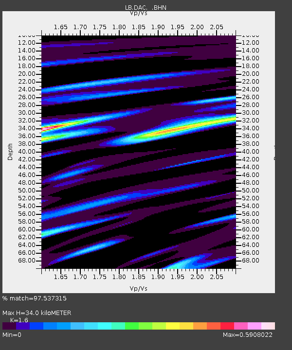
| Estimated Moho Depth: |
34.0 km |
| Estimated Crust Vp/Vs: |
1.60 |
| Assumed Crust Vp: |
6.279 km/s |
| Estimated Crust Vs: |
3.924 km/s |
| Estimated Crust Poisson's Ratio: |
0.18 |
|
| Radial Match: |
97.537315 % |
| Radial Bump: |
324 |
| Transverse Match: |
97.534805 % |
| Transverse Bump: |
322 |
| SOD ConfigId: |
2459 |
| Insert Time: |
2010-03-09 07:50:39.533 +0000 |
| GWidth: |
2.5 |
| Max Bumps: |
400 |
| Tol: |
0.001 |
|

Signal To Noise
| Channel | StoN | STA | LTA |
| LB:DAC: :BHN:20040905T15:09:06.482009Z | 0.9257919 | 1.4397972E-9 | 1.5552061E-9 |
| LB:DAC: :BHE:20040905T15:09:06.482009Z | 1.3522115 | 1.9477424E-7 | 1.4404127E-7 |
| LB:DAC: :BHZ:20040905T15:09:06.482009Z | 2.1888576 | 4.2644845E-7 | 1.9482695E-7 |
| Arrivals |
| Ps | 3.3 SECOND |
| PpPs | 14 SECOND |
| PsPs/PpSs | 17 SECOND |


