You are here: Home > Network List > LB - Leo Brady Network Stations List
> Station DAC Darwin, Inyo County, California, USA > Earthquake Result Viewer
DAC Darwin, Inyo County, California, USA - Earthquake Result Viewer
| Earthquake location: |
Chile-Argentina Border Region |
| Earthquake latitude/longitude: |
-34.9/-70.4 |
| Earthquake time(UTC): |
2004/08/28 (241) 13:41:27 GMT |
| Earthquake Depth: |
1.0 km |
| Earthquake Magnitude: |
6.1 MB, 6.3 MS, 6.5 MW, 6.5 MW |
| Earthquake Catalog/Contributor: |
WHDF/NEIC |
|
| Network: |
LB Leo Brady Network |
| Station: |
DAC Darwin, Inyo County, California, USA |
| Lat/Lon: |
36.28 N/117.59 W |
| Elevation: |
1813 m |
|
| Distance: |
83.4 deg |
| Az: |
323.349 deg |
| Baz: |
142.629 deg |
| Ray Param: |
0.046244547 |
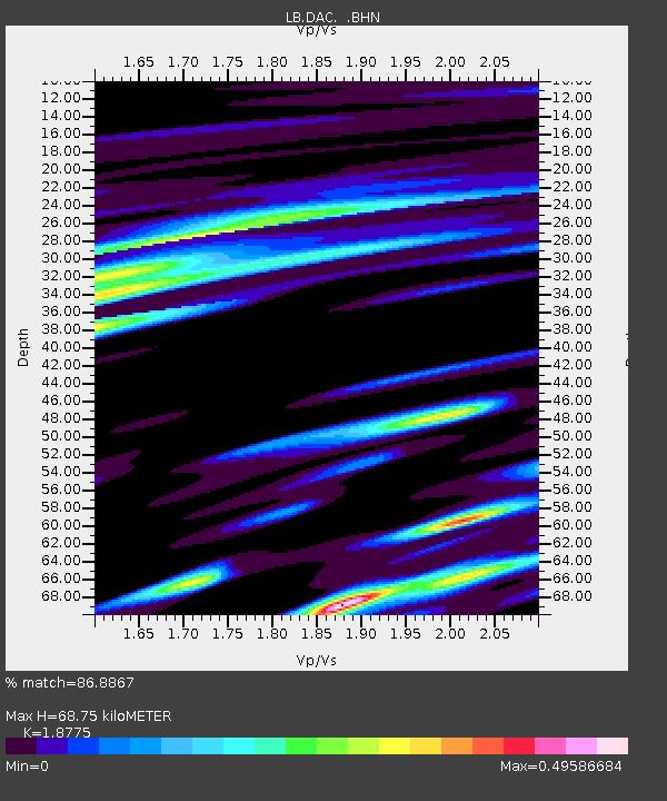
| Estimated Moho Depth: |
68.75 km |
| Estimated Crust Vp/Vs: |
1.88 |
| Assumed Crust Vp: |
6.279 km/s |
| Estimated Crust Vs: |
3.344 km/s |
| Estimated Crust Poisson's Ratio: |
0.30 |
|
| Radial Match: |
86.8867 % |
| Radial Bump: |
400 |
| Transverse Match: |
86.92652 % |
| Transverse Bump: |
400 |
| SOD ConfigId: |
2459 |
| Insert Time: |
2010-03-09 07:50:43.051 +0000 |
| GWidth: |
2.5 |
| Max Bumps: |
400 |
| Tol: |
0.001 |
|

Signal To Noise
| Channel | StoN | STA | LTA |
| LB:DAC: :BHN:20040828T13:53:25.214016Z | 2.6691658 | 3.6114023E-9 | 1.3530078E-9 |
| LB:DAC: :BHE:20040828T13:53:25.214016Z | 1.216303 | 1.0673549E-7 | 8.775404E-8 |
| LB:DAC: :BHZ:20040828T13:53:25.214016Z | 1.93026 | 2.533054E-7 | 1.3122865E-7 |
| Arrivals |
| Ps | 9.8 SECOND |
| PpPs | 31 SECOND |
| PsPs/PpSs | 41 SECOND |


