You are here: Home > Network List > TA - USArray Transportable Network (new EarthScope stations) Stations List
> Station G16K Koyuk River, AK, USA > Earthquake Result Viewer
G16K Koyuk River, AK, USA - Earthquake Result Viewer
| Earthquake location: |
Kermadec Islands, New Zealand |
| Earthquake latitude/longitude: |
-29.9/-177.6 |
| Earthquake time(UTC): |
2021/04/30 (120) 02:06:13 GMT |
| Earthquake Depth: |
16 km |
| Earthquake Magnitude: |
5.5 mb |
| Earthquake Catalog/Contributor: |
NEIC PDE/us |
|
| Network: |
TA USArray Transportable Network (new EarthScope stations) |
| Station: |
G16K Koyuk River, AK, USA |
| Lat/Lon: |
65.39 N/162.35 W |
| Elevation: |
169 m |
|
| Distance: |
95.7 deg |
| Az: |
6.349 deg |
| Baz: |
193.262 deg |
| Ray Param: |
0.040720817 |
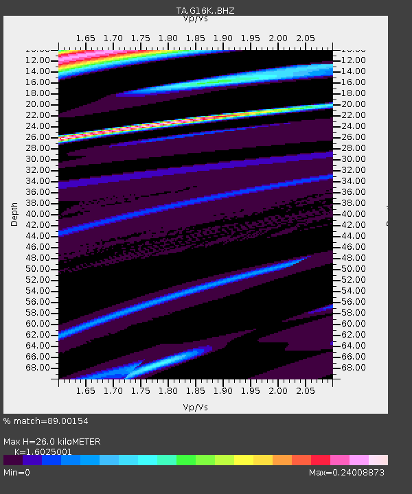
| Estimated Moho Depth: |
26.0 km |
| Estimated Crust Vp/Vs: |
1.60 |
| Assumed Crust Vp: |
6.276 km/s |
| Estimated Crust Vs: |
3.916 km/s |
| Estimated Crust Poisson's Ratio: |
0.18 |
|
| Radial Match: |
89.00154 % |
| Radial Bump: |
400 |
| Transverse Match: |
88.850975 % |
| Transverse Bump: |
400 |
| SOD ConfigId: |
24334971 |
| Insert Time: |
2021-05-14 02:17:22.500 +0000 |
| GWidth: |
2.5 |
| Max Bumps: |
400 |
| Tol: |
0.001 |
|

Signal To Noise
| Channel | StoN | STA | LTA |
| TA:G16K: :BHZ:20210430T02:19:07.050014Z | 2.2489452 | 3.1361913E-5 | 1.3945166E-5 |
| TA:G16K: :BHN:20210430T02:19:07.050014Z | 0.9031831 | 5.350353E-5 | 5.923885E-5 |
| TA:G16K: :BHE:20210430T02:19:07.050014Z | 1.017016 | 1.7855051E-7 | 1.7556312E-7 |
| Arrivals |
| Ps | 2.5 SECOND |
| PpPs | 11 SECOND |
| PsPs/PpSs | 13 SECOND |


