You are here: Home > Network List > LB - Leo Brady Network Stations List
> Station TPH Tonopah, Nevada, USA > Earthquake Result Viewer
TPH Tonopah, Nevada, USA - Earthquake Result Viewer
| Earthquake location: |
Mariana Islands |
| Earthquake latitude/longitude: |
18.9/145.4 |
| Earthquake time(UTC): |
2007/10/31 (304) 03:30:17 GMT |
| Earthquake Depth: |
223 km |
| Earthquake Magnitude: |
6.2 MB, 7.2 MW, 7.2 MW |
| Earthquake Catalog/Contributor: |
WHDF/NEIC |
|
| Network: |
LB Leo Brady Network |
| Station: |
TPH Tonopah, Nevada, USA |
| Lat/Lon: |
38.08 N/117.22 W |
| Elevation: |
1883 m |
|
| Distance: |
84.2 deg |
| Az: |
51.874 deg |
| Baz: |
289.316 deg |
| Ray Param: |
0.045113936 |
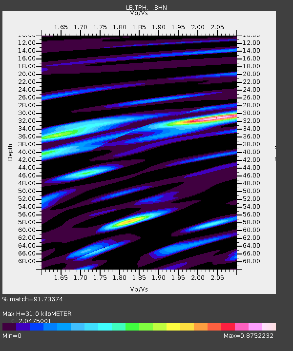
| Estimated Moho Depth: |
31.0 km |
| Estimated Crust Vp/Vs: |
2.05 |
| Assumed Crust Vp: |
6.276 km/s |
| Estimated Crust Vs: |
3.065 km/s |
| Estimated Crust Poisson's Ratio: |
0.34 |
|
| Radial Match: |
91.73674 % |
| Radial Bump: |
400 |
| Transverse Match: |
72.84239 % |
| Transverse Bump: |
400 |
| SOD ConfigId: |
2564 |
| Insert Time: |
2010-03-09 07:51:57.335 +0000 |
| GWidth: |
2.5 |
| Max Bumps: |
400 |
| Tol: |
0.001 |
|

Signal To Noise
| Channel | StoN | STA | LTA |
| LB:TPH: :BHN:20071031T03:41:52.535Z | 1.1569574 | 3.1229553E-7 | 2.699283E-7 |
| LB:TPH: :BHE:20071031T03:41:52.535Z | 4.5934925 | 1.2659142E-6 | 2.7558863E-7 |
| LB:TPH: :BHZ:20071031T03:41:52.535Z | 13.508245 | 3.3495878E-6 | 2.4796617E-7 |
| Arrivals |
| Ps | 5.3 SECOND |
| PpPs | 15 SECOND |
| PsPs/PpSs | 20 SECOND |


