You are here: Home > Network List > US - United States National Seismic Network Stations List
> Station EYMN Ely, Minnesota, USA > Earthquake Result Viewer
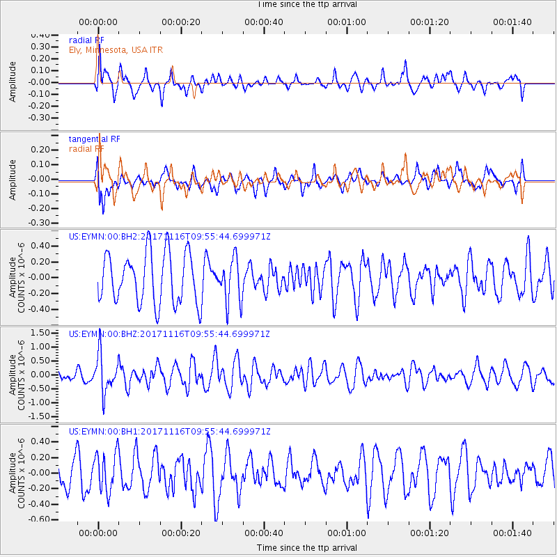
EYMN Ely, Minnesota, USA - Earthquake Result Viewer
*The percent match for this event was below the threshold and hence no stack was calculated.
| Earthquake location: |
Southeast Of Honshu, Japan |
| Earthquake latitude/longitude: |
32.2/140.5 |
| Earthquake time(UTC): |
2017/11/16 (320) 09:43:35 GMT |
| Earthquake Depth: |
71 km |
| Earthquake Magnitude: |
5.8 Mww |
| Earthquake Catalog/Contributor: |
NEIC PDE/us |
|
| Network: |
US United States National Seismic Network |
| Station: |
EYMN Ely, Minnesota, USA |
| Lat/Lon: |
47.95 N/91.50 W |
| Elevation: |
475 m |
|
| Distance: |
87.6 deg |
| Az: |
32.043 deg |
| Baz: |
317.999 deg |
| Ray Param: |
$rayparam |
*The percent match for this event was below the threshold and hence was not used in the summary stack. |
|
| Radial Match: |
46.024517 % |
| Radial Bump: |
400 |
| Transverse Match: |
64.88804 % |
| Transverse Bump: |
400 |
| SOD ConfigId: |
2429771 |
| Insert Time: |
2017-11-30 09:48:46.612 +0000 |
| GWidth: |
2.5 |
| Max Bumps: |
400 |
| Tol: |
0.001 |
|
Signal To Noise
| Channel | StoN | STA | LTA |
| US:EYMN:00:BHZ:20171116T09:55:44.699971Z | 2.8046174 | 7.0365616E-7 | 2.5089204E-7 |
| US:EYMN:00:BH1:20171116T09:55:44.699971Z | 1.2649454 | 2.535443E-7 | 2.0043893E-7 |
| US:EYMN:00:BH2:20171116T09:55:44.699971Z | 0.8816246 | 2.8193588E-7 | 3.1979133E-7 |
| Arrivals |
| Ps | |
| PpPs | |
| PsPs/PpSs | |


