You are here: Home > Network List > US - United States National Seismic Network Stations List
> Station MSO Missoula, Montana, USA > Earthquake Result Viewer
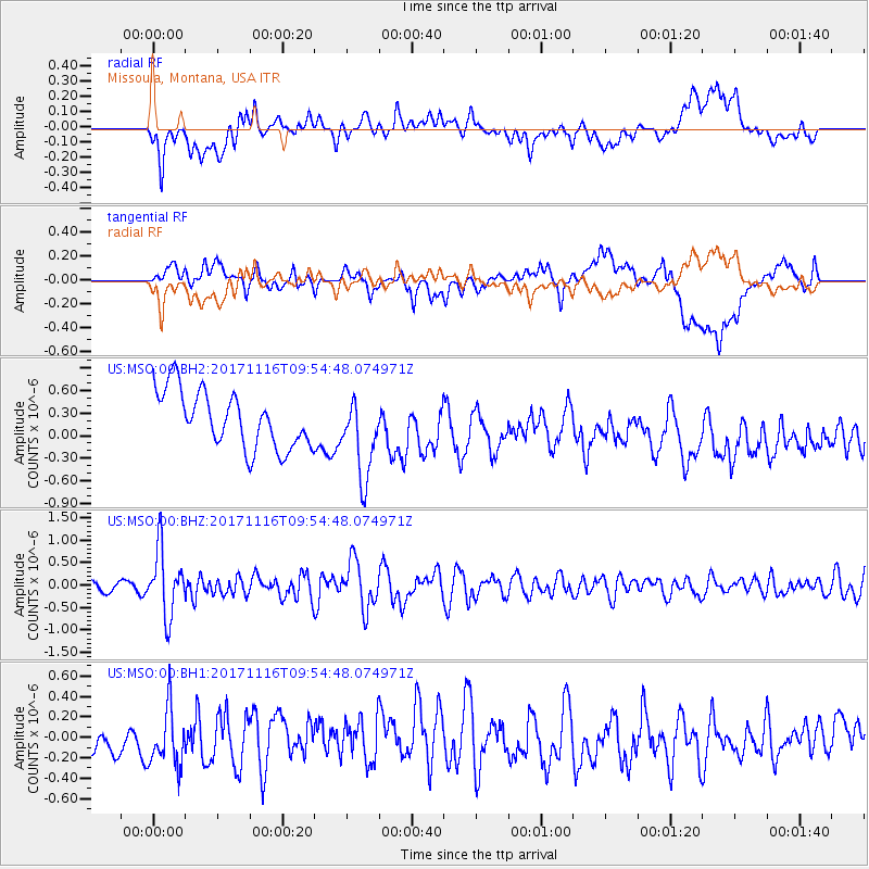
MSO Missoula, Montana, USA - Earthquake Result Viewer
*The percent match for this event was below the threshold and hence no stack was calculated.
| Earthquake location: |
Southeast Of Honshu, Japan |
| Earthquake latitude/longitude: |
32.2/140.5 |
| Earthquake time(UTC): |
2017/11/16 (320) 09:43:35 GMT |
| Earthquake Depth: |
71 km |
| Earthquake Magnitude: |
5.8 Mww |
| Earthquake Catalog/Contributor: |
NEIC PDE/us |
|
| Network: |
US United States National Seismic Network |
| Station: |
MSO Missoula, Montana, USA |
| Lat/Lon: |
46.83 N/113.94 W |
| Elevation: |
1264 m |
|
| Distance: |
76.7 deg |
| Az: |
42.826 deg |
| Baz: |
302.914 deg |
| Ray Param: |
$rayparam |
*The percent match for this event was below the threshold and hence was not used in the summary stack. |
|
| Radial Match: |
42.99445 % |
| Radial Bump: |
400 |
| Transverse Match: |
43.138935 % |
| Transverse Bump: |
400 |
| SOD ConfigId: |
2429771 |
| Insert Time: |
2017-11-30 09:49:05.667 +0000 |
| GWidth: |
2.5 |
| Max Bumps: |
400 |
| Tol: |
0.001 |
|
Signal To Noise
| Channel | StoN | STA | LTA |
| US:MSO:00:BHZ:20171116T09:54:48.074971Z | 5.590302 | 7.302816E-7 | 1.3063367E-7 |
| US:MSO:00:BH1:20171116T09:54:48.074971Z | 1.5237527 | 3.1184794E-7 | 2.0465782E-7 |
| US:MSO:00:BH2:20171116T09:54:48.074971Z | 1.4444253 | 5.4001873E-7 | 3.7386408E-7 |
| Arrivals |
| Ps | |
| PpPs | |
| PsPs/PpSs | |


