You are here: Home > Network List > AK - Alaska Regional Network Stations List
> Station E27K Coleen River, AK, USA > Earthquake Result Viewer
E27K Coleen River, AK, USA - Earthquake Result Viewer
| Earthquake location: |
Near East Coast Of Honshu, Japan |
| Earthquake latitude/longitude: |
38.1/141.8 |
| Earthquake time(UTC): |
2021/05/01 (121) 01:27:30 GMT |
| Earthquake Depth: |
56 km |
| Earthquake Magnitude: |
6.6 Mi |
| Earthquake Catalog/Contributor: |
NEIC PDE/at |
|
| Network: |
AK Alaska Regional Network |
| Station: |
E27K Coleen River, AK, USA |
| Lat/Lon: |
68.19 N/141.60 W |
| Elevation: |
654 m |
|
| Distance: |
50.3 deg |
| Az: |
28.183 deg |
| Baz: |
274.48 deg |
| Ray Param: |
0.0679697 |
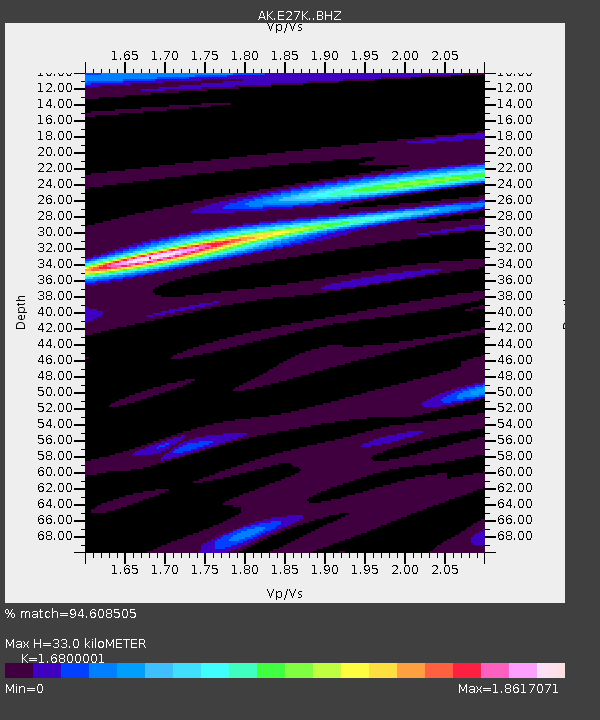
| Estimated Moho Depth: |
33.0 km |
| Estimated Crust Vp/Vs: |
1.68 |
| Assumed Crust Vp: |
6.522 km/s |
| Estimated Crust Vs: |
3.882 km/s |
| Estimated Crust Poisson's Ratio: |
0.23 |
|
| Radial Match: |
94.608505 % |
| Radial Bump: |
400 |
| Transverse Match: |
82.75836 % |
| Transverse Bump: |
400 |
| SOD ConfigId: |
24334971 |
| Insert Time: |
2021-05-15 01:33:21.987 +0000 |
| GWidth: |
2.5 |
| Max Bumps: |
400 |
| Tol: |
0.001 |
|

Signal To Noise
| Channel | StoN | STA | LTA |
| AK:E27K: :BHZ:20210501T01:35:50.679993Z | 74.60592 | 4.0372774E-6 | 5.4114707E-8 |
| AK:E27K: :BHN:20210501T01:35:50.679993Z | 8.480095 | 4.9734297E-7 | 5.864828E-8 |
| AK:E27K: :BHE:20210501T01:35:50.679993Z | 49.129124 | 2.2381778E-6 | 4.5557048E-8 |
| Arrivals |
| Ps | 3.7 SECOND |
| PpPs | 13 SECOND |
| PsPs/PpSs | 16 SECOND |


