You are here: Home > Network List > AV - Alaska Volcano Observatory Stations List
> Station SPCR Ckakachatna River, Mount Spurr, Alaska > Earthquake Result Viewer
SPCR Ckakachatna River, Mount Spurr, Alaska - Earthquake Result Viewer
| Earthquake location: |
Near East Coast Of Honshu, Japan |
| Earthquake latitude/longitude: |
38.1/141.8 |
| Earthquake time(UTC): |
2021/05/01 (121) 01:27:30 GMT |
| Earthquake Depth: |
56 km |
| Earthquake Magnitude: |
6.6 Mi |
| Earthquake Catalog/Contributor: |
NEIC PDE/at |
|
| Network: |
AV Alaska Volcano Observatory |
| Station: |
SPCR Ckakachatna River, Mount Spurr, Alaska |
| Lat/Lon: |
61.20 N/152.21 W |
| Elevation: |
984 m |
|
| Distance: |
46.1 deg |
| Az: |
37.851 deg |
| Baz: |
271.326 deg |
| Ray Param: |
0.07069905 |
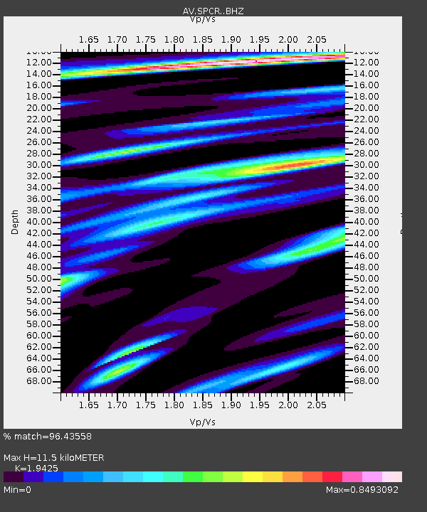
| Estimated Moho Depth: |
11.5 km |
| Estimated Crust Vp/Vs: |
1.94 |
| Assumed Crust Vp: |
6.566 km/s |
| Estimated Crust Vs: |
3.38 km/s |
| Estimated Crust Poisson's Ratio: |
0.32 |
|
| Radial Match: |
96.43558 % |
| Radial Bump: |
400 |
| Transverse Match: |
87.799904 % |
| Transverse Bump: |
400 |
| SOD ConfigId: |
24334971 |
| Insert Time: |
2021-05-15 01:36:01.833 +0000 |
| GWidth: |
2.5 |
| Max Bumps: |
400 |
| Tol: |
0.001 |
|
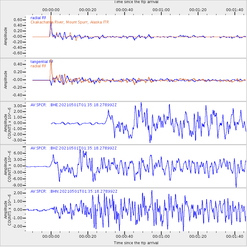
Signal To Noise
| Channel | StoN | STA | LTA |
| AV:SPCR: :BHZ:20210501T01:35:18.278992Z | 33.793194 | 3.0974852E-6 | 9.1660034E-8 |
| AV:SPCR: :BHN:20210501T01:35:18.278992Z | 3.8277602 | 3.8402578E-7 | 1.00326496E-7 |
| AV:SPCR: :BHE:20210501T01:35:18.278992Z | 11.945177 | 1.2363153E-6 | 1.0349912E-7 |
| Arrivals |
| Ps | 1.8 SECOND |
| PpPs | 4.9 SECOND |
| PsPs/PpSs | 6.6 SECOND |


