You are here: Home > Network List > LB - Leo Brady Network Stations List
> Station TPH Tonopah, Nevada, USA > Earthquake Result Viewer
TPH Tonopah, Nevada, USA - Earthquake Result Viewer
| Earthquake location: |
Eastern Siberia, Russia |
| Earthquake latitude/longitude: |
60.5/167.5 |
| Earthquake time(UTC): |
2006/04/29 (119) 16:58:06 GMT |
| Earthquake Depth: |
11 km |
| Earthquake Magnitude: |
6.4 MB, 6.6 MS, 6.6 MW, 6.4 MW |
| Earthquake Catalog/Contributor: |
WHDF/NEIC |
|
| Network: |
LB Leo Brady Network |
| Station: |
TPH Tonopah, Nevada, USA |
| Lat/Lon: |
38.08 N/117.22 W |
| Elevation: |
1883 m |
|
| Distance: |
50.7 deg |
| Az: |
80.364 deg |
| Baz: |
321.797 deg |
| Ray Param: |
0.06785765 |
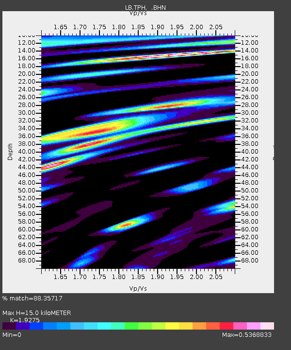
| Estimated Moho Depth: |
15.0 km |
| Estimated Crust Vp/Vs: |
1.93 |
| Assumed Crust Vp: |
6.276 km/s |
| Estimated Crust Vs: |
3.256 km/s |
| Estimated Crust Poisson's Ratio: |
0.32 |
|
| Radial Match: |
88.35717 % |
| Radial Bump: |
400 |
| Transverse Match: |
78.4828 % |
| Transverse Bump: |
400 |
| SOD ConfigId: |
2669 |
| Insert Time: |
2010-03-09 07:53:25.298 +0000 |
| GWidth: |
2.5 |
| Max Bumps: |
400 |
| Tol: |
0.001 |
|

Signal To Noise
| Channel | StoN | STA | LTA |
| LB:TPH: :BHN:20060429T17:06:35.046013Z | 2.2670715 | 3.0523395E-7 | 1.34638E-7 |
| LB:TPH: :BHE:20060429T17:06:35.046013Z | 2.6226416 | 2.2876384E-7 | 8.7226496E-8 |
| LB:TPH: :BHZ:20060429T17:06:35.046013Z | 16.355766 | 1.0291233E-6 | 6.2921124E-8 |
| Arrivals |
| Ps | 2.3 SECOND |
| PpPs | 6.7 SECOND |
| PsPs/PpSs | 9.0 SECOND |


