You are here: Home > Network List > CC - Cascade Chain Volcano Monitoring Stations List
> Station SWF2 Southwest Flank moved down hill, Mt. St. Helens, WA > Earthquake Result Viewer
SWF2 Southwest Flank moved down hill, Mt. St. Helens, WA - Earthquake Result Viewer
| Earthquake location: |
Near East Coast Of Honshu, Japan |
| Earthquake latitude/longitude: |
38.1/141.8 |
| Earthquake time(UTC): |
2021/05/01 (121) 01:27:30 GMT |
| Earthquake Depth: |
56 km |
| Earthquake Magnitude: |
6.6 Mi |
| Earthquake Catalog/Contributor: |
NEIC PDE/at |
|
| Network: |
CC Cascade Chain Volcano Monitoring |
| Station: |
SWF2 Southwest Flank moved down hill, Mt. St. Helens, WA |
| Lat/Lon: |
46.18 N/122.22 W |
| Elevation: |
1548 m |
|
| Distance: |
67.4 deg |
| Az: |
48.477 deg |
| Baz: |
301.779 deg |
| Ray Param: |
0.05689252 |
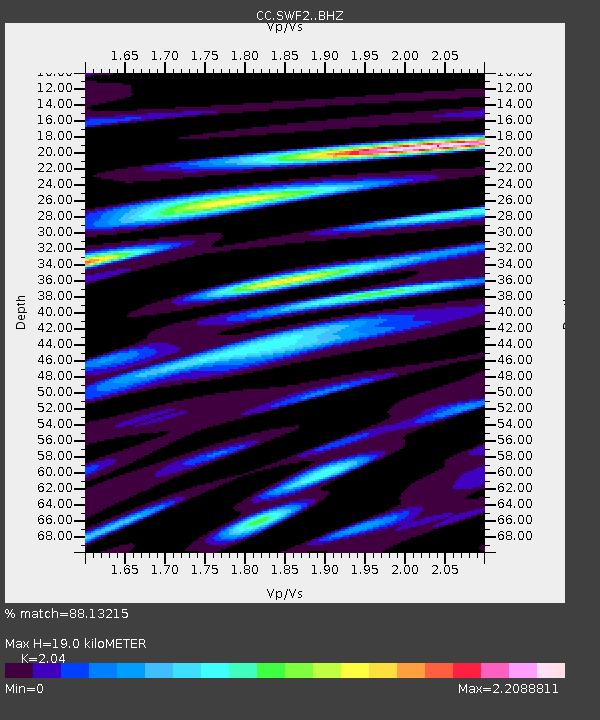
| Estimated Moho Depth: |
19.0 km |
| Estimated Crust Vp/Vs: |
2.04 |
| Assumed Crust Vp: |
6.566 km/s |
| Estimated Crust Vs: |
3.219 km/s |
| Estimated Crust Poisson's Ratio: |
0.34 |
|
| Radial Match: |
88.13215 % |
| Radial Bump: |
400 |
| Transverse Match: |
82.893486 % |
| Transverse Bump: |
400 |
| SOD ConfigId: |
24334971 |
| Insert Time: |
2021-05-15 01:38:36.614 +0000 |
| GWidth: |
2.5 |
| Max Bumps: |
400 |
| Tol: |
0.001 |
|

Signal To Noise
| Channel | StoN | STA | LTA |
| CC:SWF2: :BHZ:20210501T01:37:48.539978Z | 9.052656 | 1.4856076E-6 | 1.6410736E-7 |
| CC:SWF2: :BHN:20210501T01:37:48.539978Z | 2.0405254 | 5.376904E-7 | 2.6350588E-7 |
| CC:SWF2: :BHE:20210501T01:37:48.539978Z | 2.2976446 | 6.7528214E-7 | 2.9390188E-7 |
| Arrivals |
| Ps | 3.1 SECOND |
| PpPs | 8.5 SECOND |
| PsPs/PpSs | 12 SECOND |


