You are here: Home > Network List > LB - Leo Brady Network Stations List
> Station TPH Tonopah, Nevada, USA > Earthquake Result Viewer
TPH Tonopah, Nevada, USA - Earthquake Result Viewer
| Earthquake location: |
Near East Coast Of Honshu, Japan |
| Earthquake latitude/longitude: |
36.5/141.0 |
| Earthquake time(UTC): |
2000/07/20 (202) 18:39:18 GMT |
| Earthquake Depth: |
47 km |
| Earthquake Magnitude: |
6.1 MB, 5.4 MS, 6.1 ME, 6.0 MW |
| Earthquake Catalog/Contributor: |
WHDF/NEIC |
|
| Network: |
LB Leo Brady Network |
| Station: |
TPH Tonopah, Nevada, USA |
| Lat/Lon: |
38.08 N/117.22 W |
| Elevation: |
1883 m |
|
| Distance: |
76.5 deg |
| Az: |
52.615 deg |
| Baz: |
305.793 deg |
| Ray Param: |
0.050883777 |
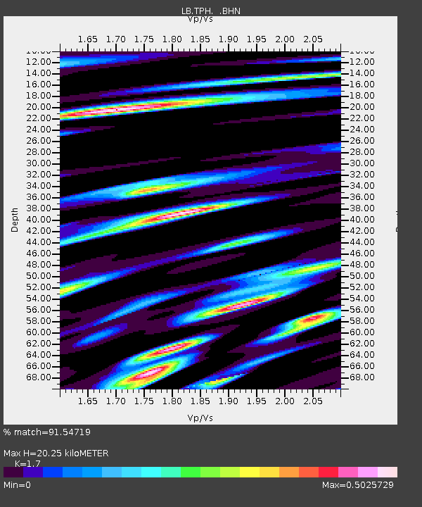
| Estimated Moho Depth: |
20.25 km |
| Estimated Crust Vp/Vs: |
1.70 |
| Assumed Crust Vp: |
6.276 km/s |
| Estimated Crust Vs: |
3.692 km/s |
| Estimated Crust Poisson's Ratio: |
0.24 |
|
| Radial Match: |
91.54719 % |
| Radial Bump: |
400 |
| Transverse Match: |
85.90442 % |
| Transverse Bump: |
400 |
| SOD ConfigId: |
20082 |
| Insert Time: |
2010-03-09 07:53:49.971 +0000 |
| GWidth: |
2.5 |
| Max Bumps: |
400 |
| Tol: |
0.001 |
|

Signal To Noise
| Channel | StoN | STA | LTA |
| LB:TPH: :BHN:20000720T18:50:32.723015Z | 2.07908 | 1.5095131E-7 | 7.2604855E-8 |
| LB:TPH: :BHE:20000720T18:50:32.723015Z | 3.1714785 | 1.9387167E-7 | 6.112974E-8 |
| LB:TPH: :BHZ:20000720T18:50:32.723015Z | 9.974125 | 8.923652E-7 | 8.946802E-8 |
| Arrivals |
| Ps | 2.3 SECOND |
| PpPs | 8.4 SECOND |
| PsPs/PpSs | 11 SECOND |


