You are here: Home > Network List > UU - University of Utah Regional Network Stations List
> Station FORU South Mineral Mountains, UT, USA > Earthquake Result Viewer
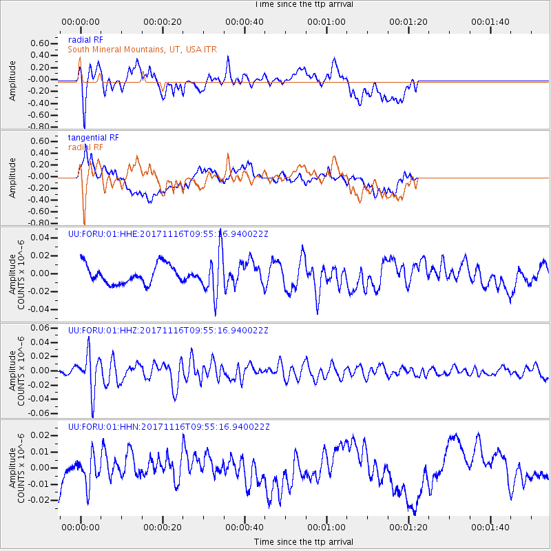
FORU South Mineral Mountains, UT, USA - Earthquake Result Viewer
*The percent match for this event was below the threshold and hence no stack was calculated.
| Earthquake location: |
Southeast Of Honshu, Japan |
| Earthquake latitude/longitude: |
32.2/140.5 |
| Earthquake time(UTC): |
2017/11/16 (320) 09:43:35 GMT |
| Earthquake Depth: |
71 km |
| Earthquake Magnitude: |
5.8 Mww |
| Earthquake Catalog/Contributor: |
NEIC PDE/us |
|
| Network: |
UU University of Utah Regional Network |
| Station: |
FORU South Mineral Mountains, UT, USA |
| Lat/Lon: |
38.46 N/112.86 W |
| Elevation: |
1840 m |
|
| Distance: |
82.1 deg |
| Az: |
49.437 deg |
| Baz: |
304.865 deg |
| Ray Param: |
$rayparam |
*The percent match for this event was below the threshold and hence was not used in the summary stack. |
|
| Radial Match: |
51.80877 % |
| Radial Bump: |
400 |
| Transverse Match: |
59.94756 % |
| Transverse Bump: |
400 |
| SOD ConfigId: |
2429771 |
| Insert Time: |
2017-11-30 09:49:40.713 +0000 |
| GWidth: |
2.5 |
| Max Bumps: |
400 |
| Tol: |
0.001 |
|
Signal To Noise
| Channel | StoN | STA | LTA |
| UU:FORU:01:HHZ:20171116T09:55:16.940022Z | 6.5799217 | 2.7052286E-8 | 4.111339E-9 |
| UU:FORU:01:HHN:20171116T09:55:16.940022Z | 0.6611737 | 8.932998E-9 | 1.3510819E-8 |
| UU:FORU:01:HHE:20171116T09:55:16.940022Z | 2.3358893 | 2.4252754E-8 | 1.0382664E-8 |
| Arrivals |
| Ps | |
| PpPs | |
| PsPs/PpSs | |


