You are here: Home > Network List > LB - Leo Brady Network Stations List
> Station TPH Tonopah, Nevada, USA > Earthquake Result Viewer
TPH Tonopah, Nevada, USA - Earthquake Result Viewer
| Earthquake location: |
Vanuatu Islands |
| Earthquake latitude/longitude: |
-14.9/167.2 |
| Earthquake time(UTC): |
2001/01/09 (009) 16:49:28 GMT |
| Earthquake Depth: |
103 km |
| Earthquake Magnitude: |
6.3 MB, 6.6 MS, 7.6 ME, 7.0 MW |
| Earthquake Catalog/Contributor: |
WHDF/NEIC |
|
| Network: |
LB Leo Brady Network |
| Station: |
TPH Tonopah, Nevada, USA |
| Lat/Lon: |
38.08 N/117.22 W |
| Elevation: |
1883 m |
|
| Distance: |
88.1 deg |
| Az: |
49.893 deg |
| Baz: |
249.526 deg |
| Ray Param: |
0.042590555 |
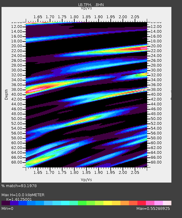
| Estimated Moho Depth: |
10.0 km |
| Estimated Crust Vp/Vs: |
1.61 |
| Assumed Crust Vp: |
6.276 km/s |
| Estimated Crust Vs: |
3.892 km/s |
| Estimated Crust Poisson's Ratio: |
0.19 |
|
| Radial Match: |
93.1978 % |
| Radial Bump: |
400 |
| Transverse Match: |
78.59621 % |
| Transverse Bump: |
400 |
| SOD ConfigId: |
20082 |
| Insert Time: |
2010-03-09 07:54:17.631 +0000 |
| GWidth: |
2.5 |
| Max Bumps: |
400 |
| Tol: |
0.001 |
|

Signal To Noise
| Channel | StoN | STA | LTA |
| LB:TPH: :BHN:20010109T17:01:36.046021Z | 1.120788 | 3.2824818E-7 | 2.928727E-7 |
| LB:TPH: :BHE:20010109T17:01:36.046021Z | 9.112016 | 8.458808E-7 | 9.283135E-8 |
| LB:TPH: :BHZ:20010109T17:01:36.046021Z | 13.513471 | 2.4298777E-6 | 1.7981152E-7 |
| Arrivals |
| Ps | 1.0 SECOND |
| PpPs | 4.1 SECOND |
| PsPs/PpSs | 5.1 SECOND |


