You are here: Home > Network List > GS - US Geological Survey Networks Stations List
> Station ASA6 ASA6 > Earthquake Result Viewer
ASA6 ASA6 - Earthquake Result Viewer
| Earthquake location: |
Near East Coast Of Honshu, Japan |
| Earthquake latitude/longitude: |
38.1/141.8 |
| Earthquake time(UTC): |
2021/05/01 (121) 01:27:30 GMT |
| Earthquake Depth: |
56 km |
| Earthquake Magnitude: |
6.6 Mi |
| Earthquake Catalog/Contributor: |
NEIC PDE/at |
|
| Network: |
GS US Geological Survey Networks |
| Station: |
ASA6 ASA6 |
| Lat/Lon: |
34.94 N/106.46 W |
| Elevation: |
1840 m |
|
| Distance: |
83.7 deg |
| Az: |
50.152 deg |
| Baz: |
312.498 deg |
| Ray Param: |
0.045923136 |
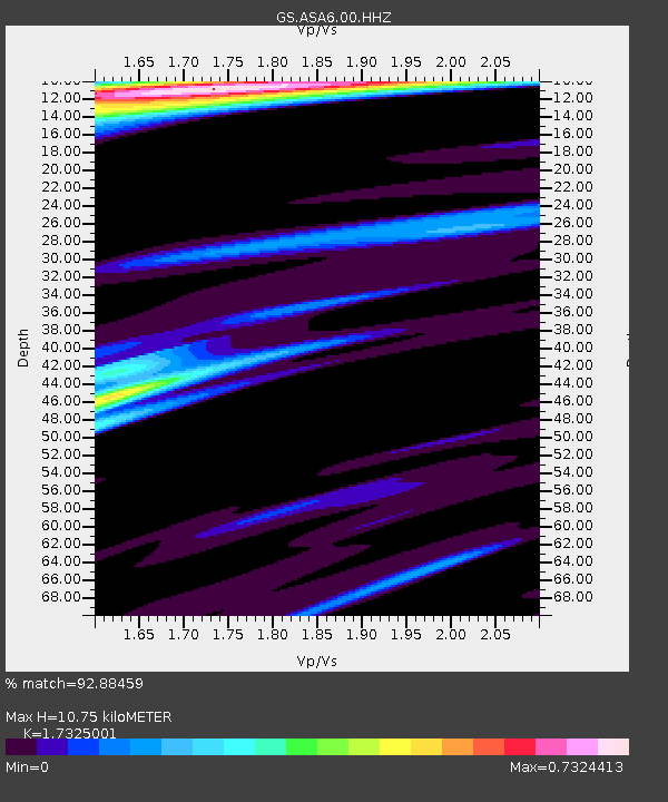
| Estimated Moho Depth: |
10.75 km |
| Estimated Crust Vp/Vs: |
1.73 |
| Assumed Crust Vp: |
6.502 km/s |
| Estimated Crust Vs: |
3.753 km/s |
| Estimated Crust Poisson's Ratio: |
0.25 |
|
| Radial Match: |
92.88459 % |
| Radial Bump: |
283 |
| Transverse Match: |
84.441086 % |
| Transverse Bump: |
400 |
| SOD ConfigId: |
24334971 |
| Insert Time: |
2021-05-15 01:46:17.269 +0000 |
| GWidth: |
2.5 |
| Max Bumps: |
400 |
| Tol: |
0.001 |
|

Signal To Noise
| Channel | StoN | STA | LTA |
| GS:ASA6:00:HHZ:20210501T01:39:21.51001Z | 10.493994 | 1.3955083E-6 | 1.3298163E-7 |
| GS:ASA6:00:HH1:20210501T01:39:21.51001Z | 5.619305 | 3.672397E-7 | 6.535322E-8 |
| GS:ASA6:00:HH2:20210501T01:39:21.51001Z | 7.643937 | 4.3429233E-7 | 5.681527E-8 |
| Arrivals |
| Ps | 1.2 SECOND |
| PpPs | 4.4 SECOND |
| PsPs/PpSs | 5.6 SECOND |


