You are here: Home > Network List > GS - US Geological Survey Networks Stations List
> Station DEC09 Kile Street Surface Site > Earthquake Result Viewer
DEC09 Kile Street Surface Site - Earthquake Result Viewer
| Earthquake location: |
Near East Coast Of Honshu, Japan |
| Earthquake latitude/longitude: |
38.1/141.8 |
| Earthquake time(UTC): |
2021/05/01 (121) 01:27:30 GMT |
| Earthquake Depth: |
56 km |
| Earthquake Magnitude: |
6.6 Mi |
| Earthquake Catalog/Contributor: |
NEIC PDE/at |
|
| Network: |
GS US Geological Survey Networks |
| Station: |
DEC09 Kile Street Surface Site |
| Lat/Lon: |
39.87 N/88.92 W |
| Elevation: |
207 m |
|
| Distance: |
89.5 deg |
| Az: |
36.566 deg |
| Baz: |
322.357 deg |
| Ray Param: |
0.041733023 |
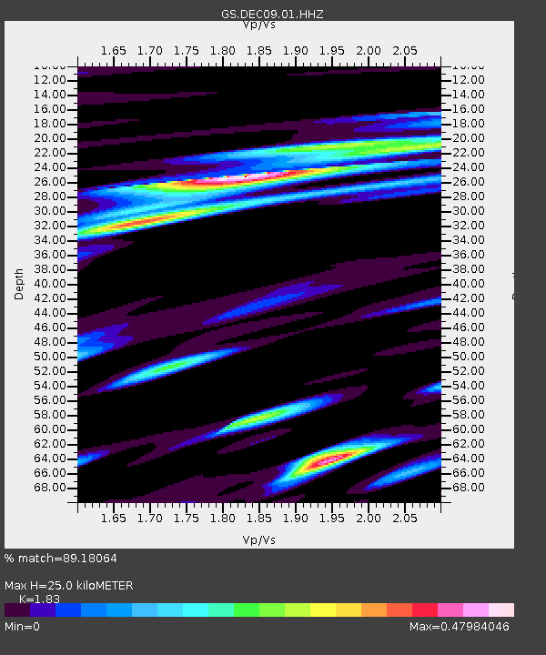
| Estimated Moho Depth: |
25.0 km |
| Estimated Crust Vp/Vs: |
1.83 |
| Assumed Crust Vp: |
6.444 km/s |
| Estimated Crust Vs: |
3.521 km/s |
| Estimated Crust Poisson's Ratio: |
0.29 |
|
| Radial Match: |
89.18064 % |
| Radial Bump: |
379 |
| Transverse Match: |
76.621 % |
| Transverse Bump: |
400 |
| SOD ConfigId: |
24334971 |
| Insert Time: |
2021-05-15 01:46:26.449 +0000 |
| GWidth: |
2.5 |
| Max Bumps: |
400 |
| Tol: |
0.001 |
|
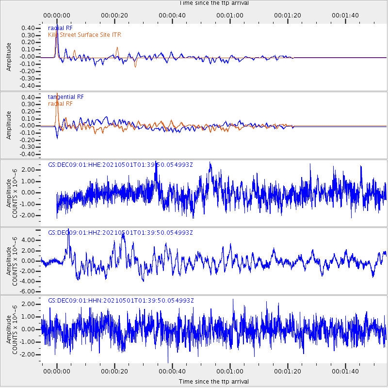
Signal To Noise
| Channel | StoN | STA | LTA |
| GS:DEC09:01:HHZ:20210501T01:39:50.054993Z | 6.5506806 | 1.9910833E-6 | 3.039506E-7 |
| GS:DEC09:01:HHN:20210501T01:39:50.054993Z | 1.2195784 | 7.127921E-7 | 5.844578E-7 |
| GS:DEC09:01:HHE:20210501T01:39:50.054993Z | 1.7859839 | 1.0102908E-6 | 5.6567745E-7 |
| Arrivals |
| Ps | 3.3 SECOND |
| PpPs | 11 SECOND |
| PsPs/PpSs | 14 SECOND |


