You are here: Home > Network List > II - Global Seismograph Network (GSN - IRIS/IDA) Stations List
> Station KURK Kurchatov, Kazakhstan > Earthquake Result Viewer
KURK Kurchatov, Kazakhstan - Earthquake Result Viewer
| Earthquake location: |
Near East Coast Of Honshu, Japan |
| Earthquake latitude/longitude: |
38.1/141.8 |
| Earthquake time(UTC): |
2021/05/01 (121) 01:27:30 GMT |
| Earthquake Depth: |
56 km |
| Earthquake Magnitude: |
6.6 Mi |
| Earthquake Catalog/Contributor: |
NEIC PDE/at |
|
| Network: |
II Global Seismograph Network (GSN - IRIS/IDA) |
| Station: |
KURK Kurchatov, Kazakhstan |
| Lat/Lon: |
50.72 N/78.62 E |
| Elevation: |
184 m |
|
| Distance: |
45.5 deg |
| Az: |
307.336 deg |
| Baz: |
80.656 deg |
| Ray Param: |
0.07105987 |
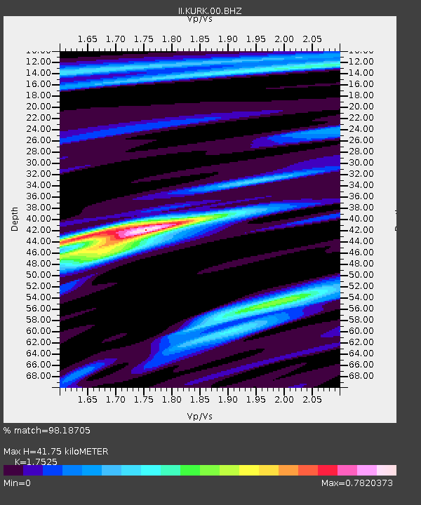
| Estimated Moho Depth: |
41.75 km |
| Estimated Crust Vp/Vs: |
1.75 |
| Assumed Crust Vp: |
6.552 km/s |
| Estimated Crust Vs: |
3.739 km/s |
| Estimated Crust Poisson's Ratio: |
0.26 |
|
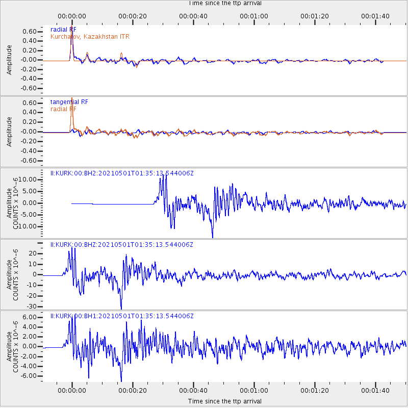
| Radial Match: |
98.18705 % |
| Radial Bump: |
361 |
| Transverse Match: |
89.99567 % |
| Transverse Bump: |
400 |
| SOD ConfigId: |
24334971 |
| Insert Time: |
2021-05-15 01:47:12.894 +0000 |
| GWidth: |
2.5 |
| Max Bumps: |
400 |
| Tol: |
0.001 |
|
Signal To Noise
| Channel | StoN | STA | LTA |
| II:KURK:00:BHZ:20210501T01:35:13.544006Z | 194.14075 | 1.2793316E-5 | 6.589712E-8 |
| II:KURK:00:BH1:20210501T01:35:13.544006Z | 71.83796 | 2.847119E-6 | 3.9632514E-8 |
| II:KURK:00:BH2:20210501T01:35:13.544006Z | 71.488785 | 6.631932E-6 | 9.276884E-8 |
| Arrivals |
| Ps | 5.1 SECOND |
| PpPs | 16 SECOND |
| PsPs/PpSs | 22 SECOND |


