You are here: Home > Network List > II - Global Seismograph Network (GSN - IRIS/IDA) Stations List
> Station PFO Pinon Flat, California, USA > Earthquake Result Viewer
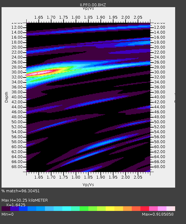
PFO Pinon Flat, California, USA - Earthquake Result Viewer
| Earthquake location: |
Near East Coast Of Honshu, Japan |
| Earthquake latitude/longitude: |
38.1/141.8 |
| Earthquake time(UTC): |
2021/05/01 (121) 01:27:30 GMT |
| Earthquake Depth: |
56 km |
| Earthquake Magnitude: |
6.6 Mi |
| Earthquake Catalog/Contributor: |
NEIC PDE/at |
|
| Network: |
II Global Seismograph Network (GSN - IRIS/IDA) |
| Station: |
PFO Pinon Flat, California, USA |
| Lat/Lon: |
33.61 N/116.46 W |
| Elevation: |
1280 m |
|
| Distance: |
78.2 deg |
| Az: |
56.585 deg |
| Baz: |
307.898 deg |
| Ray Param: |
0.04970412 |
| Estimated Moho Depth: |
30.25 km |
| Estimated Crust Vp/Vs: |
1.64 |
| Assumed Crust Vp: |
6.264 km/s |
| Estimated Crust Vs: |
3.813 km/s |
| Estimated Crust Poisson's Ratio: |
0.21 |
|
| Radial Match: |
96.30451 % |
| Radial Bump: |
264 |
| Transverse Match: |
85.36268 % |
| Transverse Bump: |
397 |
| SOD ConfigId: |
24334971 |
| Insert Time: |
2021-05-15 01:47:16.427 +0000 |
| GWidth: |
2.5 |
| Max Bumps: |
400 |
| Tol: |
0.001 |
|

Signal To Noise
| Channel | StoN | STA | LTA |
| II:PFO:00:BHZ:20210501T01:38:52.494019Z | 7.0562053 | 1.0027825E-6 | 1.4211356E-7 |
| II:PFO:00:BH1:20210501T01:38:52.494019Z | 5.206821 | 4.4276715E-7 | 8.5035985E-8 |
| II:PFO:00:BH2:20210501T01:38:52.494019Z | 1.5228018 | 1.7148997E-7 | 1.1261477E-7 |
| Arrivals |
| Ps | 3.2 SECOND |
| PpPs | 12 SECOND |
| PsPs/PpSs | 16 SECOND |


