You are here: Home > Network List > IW - Intermountain West Stations List
> Station MFID Near Bowns Crk and Slater Flat Rd, Idaho, USA > Earthquake Result Viewer
MFID Near Bowns Crk and Slater Flat Rd, Idaho, USA - Earthquake Result Viewer
| Earthquake location: |
Near East Coast Of Honshu, Japan |
| Earthquake latitude/longitude: |
38.1/141.8 |
| Earthquake time(UTC): |
2021/05/01 (121) 01:27:30 GMT |
| Earthquake Depth: |
56 km |
| Earthquake Magnitude: |
6.6 Mi |
| Earthquake Catalog/Contributor: |
NEIC PDE/at |
|
| Network: |
IW Intermountain West |
| Station: |
MFID Near Bowns Crk and Slater Flat Rd, Idaho, USA |
| Lat/Lon: |
43.42 N/115.83 W |
| Elevation: |
1302 m |
|
| Distance: |
72.7 deg |
| Az: |
48.207 deg |
| Baz: |
306.177 deg |
| Ray Param: |
0.05339783 |
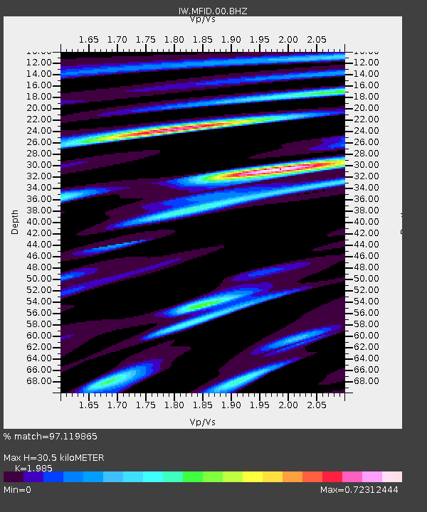
| Estimated Moho Depth: |
30.5 km |
| Estimated Crust Vp/Vs: |
1.99 |
| Assumed Crust Vp: |
6.291 km/s |
| Estimated Crust Vs: |
3.169 km/s |
| Estimated Crust Poisson's Ratio: |
0.33 |
|
| Radial Match: |
97.119865 % |
| Radial Bump: |
318 |
| Transverse Match: |
88.5269 % |
| Transverse Bump: |
400 |
| SOD ConfigId: |
24334971 |
| Insert Time: |
2021-05-15 01:48:03.429 +0000 |
| GWidth: |
2.5 |
| Max Bumps: |
400 |
| Tol: |
0.001 |
|

Signal To Noise
| Channel | StoN | STA | LTA |
| IW:MFID:00:BHZ:20210501T01:38:20.999023Z | 19.273773 | 1.5231012E-6 | 7.902455E-8 |
| IW:MFID:00:BH1:20210501T01:38:20.999023Z | 9.011409 | 4.5377138E-7 | 5.0355208E-8 |
| IW:MFID:00:BH2:20210501T01:38:20.999023Z | 7.5278463 | 5.3170163E-7 | 7.063131E-8 |
| Arrivals |
| Ps | 4.9 SECOND |
| PpPs | 14 SECOND |
| PsPs/PpSs | 19 SECOND |


