You are here: Home > Network List > MB - Montana Regional Seismic Network Stations List
> Station BUT Butte, Montana > Earthquake Result Viewer
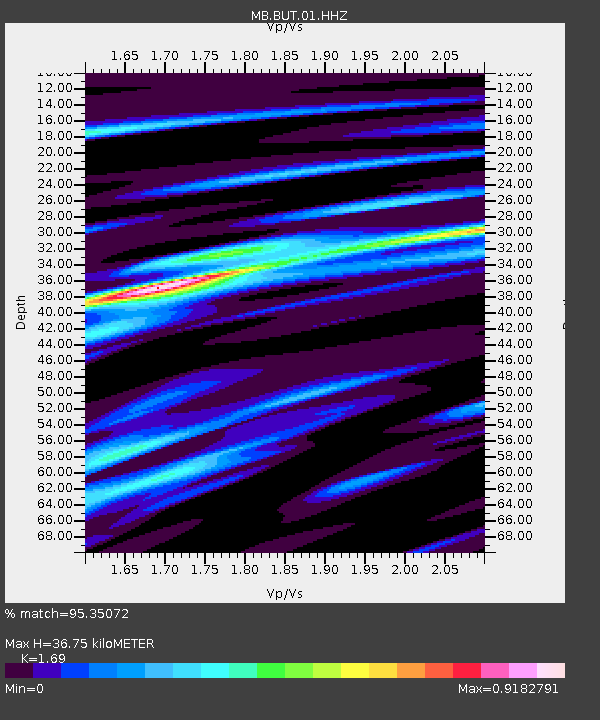
BUT Butte, Montana - Earthquake Result Viewer
| Earthquake location: |
Near East Coast Of Honshu, Japan |
| Earthquake latitude/longitude: |
38.1/141.8 |
| Earthquake time(UTC): |
2021/05/01 (121) 01:27:30 GMT |
| Earthquake Depth: |
56 km |
| Earthquake Magnitude: |
6.6 Mi |
| Earthquake Catalog/Contributor: |
NEIC PDE/at |
|
| Network: |
MB Montana Regional Seismic Network |
| Station: |
BUT Butte, Montana |
| Lat/Lon: |
46.01 N/112.56 W |
| Elevation: |
1758 m |
|
| Distance: |
73.0 deg |
| Az: |
44.571 deg |
| Baz: |
307.398 deg |
| Ray Param: |
0.053185653 |
| Estimated Moho Depth: |
36.75 km |
| Estimated Crust Vp/Vs: |
1.69 |
| Assumed Crust Vp: |
6.353 km/s |
| Estimated Crust Vs: |
3.759 km/s |
| Estimated Crust Poisson's Ratio: |
0.23 |
|
| Radial Match: |
95.35072 % |
| Radial Bump: |
311 |
| Transverse Match: |
56.54805 % |
| Transverse Bump: |
400 |
| SOD ConfigId: |
24334971 |
| Insert Time: |
2021-05-15 01:49:26.776 +0000 |
| GWidth: |
2.5 |
| Max Bumps: |
400 |
| Tol: |
0.001 |
|

Signal To Noise
| Channel | StoN | STA | LTA |
| MB:BUT:01:HHZ:20210501T01:38:22.849976Z | 16.77718 | 3.2585565E-6 | 1.9422552E-7 |
| MB:BUT:01:HHN:20210501T01:38:22.849976Z | 4.689837 | 1.2085626E-6 | 2.5769822E-7 |
| MB:BUT:01:HHE:20210501T01:38:22.849976Z | 5.755421 | 1.1760438E-6 | 2.0433671E-7 |
| Arrivals |
| Ps | 4.1 SECOND |
| PpPs | 15 SECOND |
| PsPs/PpSs | 19 SECOND |


