You are here: Home > Network List > N4 - Central and EAstern US Network Stations List
> Station K30B Basset, NE, USA > Earthquake Result Viewer
K30B Basset, NE, USA - Earthquake Result Viewer
| Earthquake location: |
Near East Coast Of Honshu, Japan |
| Earthquake latitude/longitude: |
38.1/141.8 |
| Earthquake time(UTC): |
2021/05/01 (121) 01:27:30 GMT |
| Earthquake Depth: |
56 km |
| Earthquake Magnitude: |
6.6 Mi |
| Earthquake Catalog/Contributor: |
NEIC PDE/at |
|
| Network: |
N4 Central and EAstern US Network |
| Station: |
K30B Basset, NE, USA |
| Lat/Lon: |
42.67 N/99.61 W |
| Elevation: |
712 m |
|
| Distance: |
82.1 deg |
| Az: |
40.822 deg |
| Baz: |
315.628 deg |
| Ray Param: |
0.046988536 |
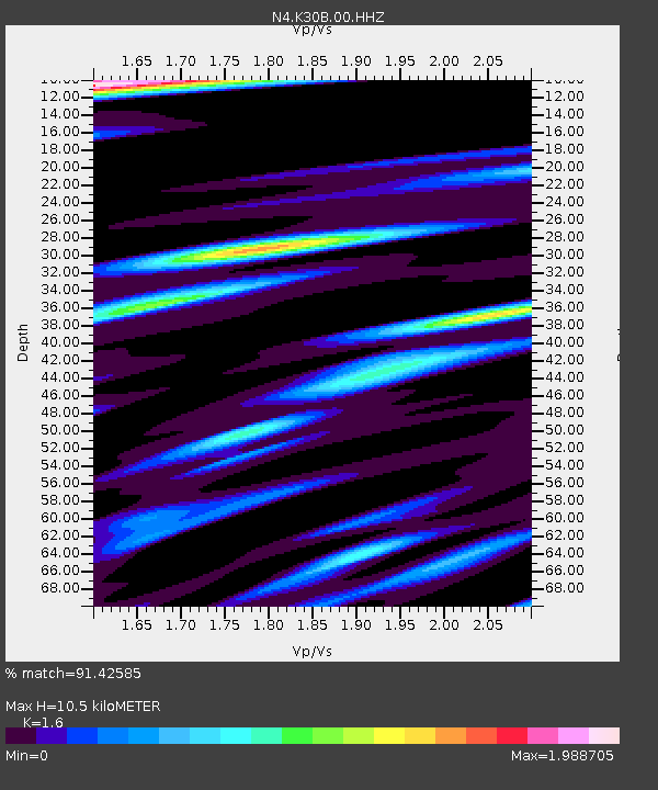
| Estimated Moho Depth: |
10.5 km |
| Estimated Crust Vp/Vs: |
1.60 |
| Assumed Crust Vp: |
6.53 km/s |
| Estimated Crust Vs: |
4.082 km/s |
| Estimated Crust Poisson's Ratio: |
0.18 |
|
| Radial Match: |
91.42585 % |
| Radial Bump: |
400 |
| Transverse Match: |
76.53901 % |
| Transverse Bump: |
400 |
| SOD ConfigId: |
24334971 |
| Insert Time: |
2021-05-15 01:50:47.890 +0000 |
| GWidth: |
2.5 |
| Max Bumps: |
400 |
| Tol: |
0.001 |
|

Signal To Noise
| Channel | StoN | STA | LTA |
| N4:K30B:00:HHZ:20210501T01:39:13.679993Z | 27.149204 | 2.6673054E-6 | 9.824617E-8 |
| N4:K30B:00:HH1:20210501T01:39:13.679993Z | 3.8719542 | 9.237609E-7 | 2.3857746E-7 |
| N4:K30B:00:HH2:20210501T01:39:13.679993Z | 3.1129134 | 7.4727905E-7 | 2.4005777E-7 |
| Arrivals |
| Ps | 1.0 SECOND |
| PpPs | 4.1 SECOND |
| PsPs/PpSs | 5.0 SECOND |


