You are here: Home > Network List > N4 - Central and EAstern US Network Stations List
> Station N38B Corydon, IA, USA > Earthquake Result Viewer
N38B Corydon, IA, USA - Earthquake Result Viewer
| Earthquake location: |
Near East Coast Of Honshu, Japan |
| Earthquake latitude/longitude: |
38.1/141.8 |
| Earthquake time(UTC): |
2021/05/01 (121) 01:27:30 GMT |
| Earthquake Depth: |
56 km |
| Earthquake Magnitude: |
6.6 Mi |
| Earthquake Catalog/Contributor: |
NEIC PDE/at |
|
| Network: |
N4 Central and EAstern US Network |
| Station: |
N38B Corydon, IA, USA |
| Lat/Lon: |
40.79 N/93.24 W |
| Elevation: |
322 m |
|
| Distance: |
86.8 deg |
| Az: |
38.55 deg |
| Baz: |
319.641 deg |
| Ray Param: |
0.043725494 |
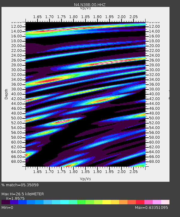
| Estimated Moho Depth: |
26.5 km |
| Estimated Crust Vp/Vs: |
1.96 |
| Assumed Crust Vp: |
6.498 km/s |
| Estimated Crust Vs: |
3.319 km/s |
| Estimated Crust Poisson's Ratio: |
0.32 |
|
| Radial Match: |
85.35859 % |
| Radial Bump: |
400 |
| Transverse Match: |
57.66017 % |
| Transverse Bump: |
400 |
| SOD ConfigId: |
24334971 |
| Insert Time: |
2021-05-15 01:51:15.079 +0000 |
| GWidth: |
2.5 |
| Max Bumps: |
400 |
| Tol: |
0.001 |
|

Signal To Noise
| Channel | StoN | STA | LTA |
| N4:N38B:00:HHZ:20210501T01:39:36.849976Z | 22.295227 | 2.6624036E-6 | 1.1941586E-7 |
| N4:N38B:00:HH1:20210501T01:39:36.849976Z | 7.1972637 | 1.2857491E-6 | 1.7864416E-7 |
| N4:N38B:00:HH2:20210501T01:39:36.849976Z | 3.9886322 | 9.167773E-7 | 2.2984753E-7 |
| Arrivals |
| Ps | 4.0 SECOND |
| PpPs | 12 SECOND |
| PsPs/PpSs | 16 SECOND |


