You are here: Home > Network List > NN - Western Great Basin/Eastern Sierra Nevada Stations List
> Station TBRD Thunderbird Lodge, Lake Tahoe, NV > Earthquake Result Viewer
TBRD Thunderbird Lodge, Lake Tahoe, NV - Earthquake Result Viewer
| Earthquake location: |
Near East Coast Of Honshu, Japan |
| Earthquake latitude/longitude: |
38.1/141.8 |
| Earthquake time(UTC): |
2021/05/01 (121) 01:27:30 GMT |
| Earthquake Depth: |
56 km |
| Earthquake Magnitude: |
6.6 Mi |
| Earthquake Catalog/Contributor: |
NEIC PDE/at |
|
| Network: |
NN Western Great Basin/Eastern Sierra Nevada |
| Station: |
TBRD Thunderbird Lodge, Lake Tahoe, NV |
| Lat/Lon: |
39.17 N/119.93 W |
| Elevation: |
1952 m |
|
| Distance: |
72.6 deg |
| Az: |
53.701 deg |
| Baz: |
305.115 deg |
| Ray Param: |
0.05342726 |
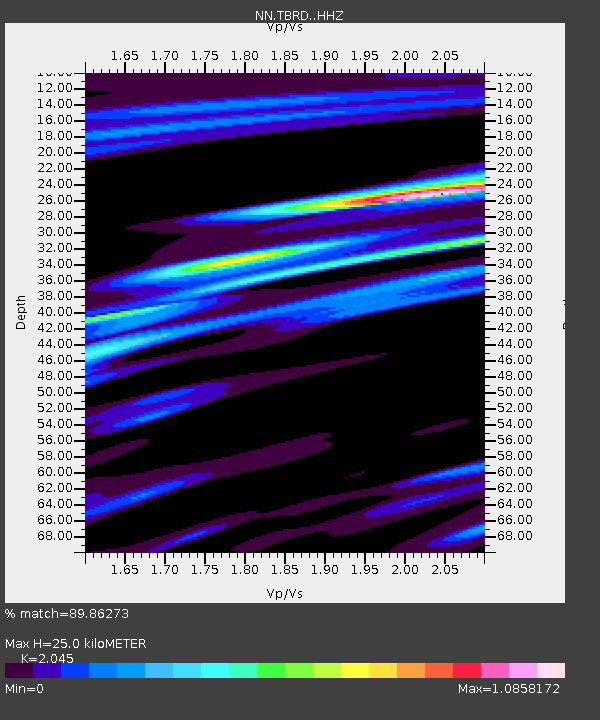
| Estimated Moho Depth: |
25.0 km |
| Estimated Crust Vp/Vs: |
2.05 |
| Assumed Crust Vp: |
6.279 km/s |
| Estimated Crust Vs: |
3.07 km/s |
| Estimated Crust Poisson's Ratio: |
0.34 |
|
| Radial Match: |
89.86273 % |
| Radial Bump: |
341 |
| Transverse Match: |
78.36712 % |
| Transverse Bump: |
400 |
| SOD ConfigId: |
24334971 |
| Insert Time: |
2021-05-15 01:54:02.868 +0000 |
| GWidth: |
2.5 |
| Max Bumps: |
400 |
| Tol: |
0.001 |
|

Signal To Noise
| Channel | StoN | STA | LTA |
| NN:TBRD: :HHZ:20210501T01:38:20.728027Z | 6.534968 | 1.064664E-6 | 1.6291803E-7 |
| NN:TBRD: :HHN:20210501T01:38:20.728027Z | 1.8815649 | 2.3282306E-7 | 1.2373906E-7 |
| NN:TBRD: :HHE:20210501T01:38:20.728027Z | 3.0095723 | 2.959928E-7 | 9.835046E-8 |
| Arrivals |
| Ps | 4.3 SECOND |
| PpPs | 12 SECOND |
| PsPs/PpSs | 16 SECOND |


