You are here: Home > Network List > NW - Northwestern University Seismic Network Stations List
> Station L44A Ryerson Woods, Lake Cnty Forest Preserve, IL, USA > Earthquake Result Viewer
L44A Ryerson Woods, Lake Cnty Forest Preserve, IL, USA - Earthquake Result Viewer
| Earthquake location: |
Near East Coast Of Honshu, Japan |
| Earthquake latitude/longitude: |
38.1/141.8 |
| Earthquake time(UTC): |
2021/05/01 (121) 01:27:30 GMT |
| Earthquake Depth: |
56 km |
| Earthquake Magnitude: |
6.6 Mi |
| Earthquake Catalog/Contributor: |
NEIC PDE/at |
|
| Network: |
NW Northwestern University Seismic Network |
| Station: |
L44A Ryerson Woods, Lake Cnty Forest Preserve, IL, USA |
| Lat/Lon: |
42.18 N/87.91 W |
| Elevation: |
202 m |
|
| Distance: |
88.2 deg |
| Az: |
34.561 deg |
| Baz: |
322.979 deg |
| Ray Param: |
0.04268611 |
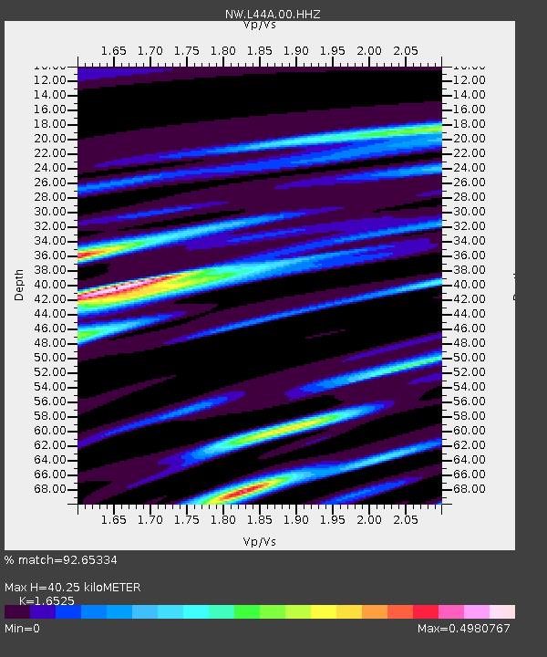
| Estimated Moho Depth: |
40.25 km |
| Estimated Crust Vp/Vs: |
1.65 |
| Assumed Crust Vp: |
6.483 km/s |
| Estimated Crust Vs: |
3.923 km/s |
| Estimated Crust Poisson's Ratio: |
0.21 |
|
| Radial Match: |
92.65334 % |
| Radial Bump: |
400 |
| Transverse Match: |
70.44617 % |
| Transverse Bump: |
400 |
| SOD ConfigId: |
24334971 |
| Insert Time: |
2021-05-15 01:54:27.165 +0000 |
| GWidth: |
2.5 |
| Max Bumps: |
400 |
| Tol: |
0.001 |
|

Signal To Noise
| Channel | StoN | STA | LTA |
| NW:L44A:00:HHZ:20210501T01:39:43.658997Z | 10.176732 | 2.5500765E-6 | 2.5057912E-7 |
| NW:L44A:00:HH1:20210501T01:39:43.658997Z | 3.96204 | 7.838093E-7 | 1.9782973E-7 |
| NW:L44A:00:HH2:20210501T01:39:43.658997Z | 2.160941 | 5.2350856E-7 | 2.4225957E-7 |
| Arrivals |
| Ps | 4.1 SECOND |
| PpPs | 16 SECOND |
| PsPs/PpSs | 20 SECOND |


