You are here: Home > Network List > NX - Nanometrics Research Network Stations List
> Station WTX29 Z > Earthquake Result Viewer
WTX29 Z - Earthquake Result Viewer
| Earthquake location: |
Near East Coast Of Honshu, Japan |
| Earthquake latitude/longitude: |
38.1/141.8 |
| Earthquake time(UTC): |
2021/05/01 (121) 01:27:30 GMT |
| Earthquake Depth: |
56 km |
| Earthquake Magnitude: |
6.6 Mi |
| Earthquake Catalog/Contributor: |
NEIC PDE/at |
|
| Network: |
NX Nanometrics Research Network |
| Station: |
WTX29 Z |
| Lat/Lon: |
32.74 N/103.56 W |
| Elevation: |
1207 m |
|
| Distance: |
86.9 deg |
| Az: |
50.095 deg |
| Baz: |
314.101 deg |
| Ray Param: |
0.043594044 |
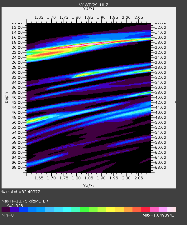
| Estimated Moho Depth: |
18.75 km |
| Estimated Crust Vp/Vs: |
1.83 |
| Assumed Crust Vp: |
6.129 km/s |
| Estimated Crust Vs: |
3.358 km/s |
| Estimated Crust Poisson's Ratio: |
0.29 |
|
| Radial Match: |
82.49372 % |
| Radial Bump: |
400 |
| Transverse Match: |
61.54478 % |
| Transverse Bump: |
400 |
| SOD ConfigId: |
24334971 |
| Insert Time: |
2021-05-15 01:54:33.824 +0000 |
| GWidth: |
2.5 |
| Max Bumps: |
400 |
| Tol: |
0.001 |
|

Signal To Noise
| Channel | StoN | STA | LTA |
| NX:WTX29: :HHZ:20210501T01:39:37.710022Z | 9.138513 | 6.5677034E-7 | 7.1868406E-8 |
| NX:WTX29: :HHN:20210501T01:39:37.710022Z | 2.3683696 | 1.8564543E-7 | 7.838533E-8 |
| NX:WTX29: :HHE:20210501T01:39:37.710022Z | 2.45419 | 1.9815619E-7 | 8.0742E-8 |
| Arrivals |
| Ps | 2.6 SECOND |
| PpPs | 8.5 SECOND |
| PsPs/PpSs | 11 SECOND |


