You are here: Home > Network List > O2 - Oklahoma Consolidated Temporary Seismic Networks Stations List
> Station PERY Perry, Oklahoma, USA > Earthquake Result Viewer
PERY Perry, Oklahoma, USA - Earthquake Result Viewer
| Earthquake location: |
Near East Coast Of Honshu, Japan |
| Earthquake latitude/longitude: |
38.1/141.8 |
| Earthquake time(UTC): |
2021/05/01 (121) 01:27:30 GMT |
| Earthquake Depth: |
56 km |
| Earthquake Magnitude: |
6.6 Mi |
| Earthquake Catalog/Contributor: |
NEIC PDE/at |
|
| Network: |
O2 Oklahoma Consolidated Temporary Seismic Networks |
| Station: |
PERY Perry, Oklahoma, USA |
| Lat/Lon: |
36.26 N/97.24 W |
| Elevation: |
209 m |
|
| Distance: |
88.1 deg |
| Az: |
43.903 deg |
| Baz: |
317.399 deg |
| Ray Param: |
0.0427676 |
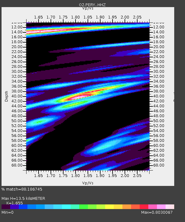
| Estimated Moho Depth: |
13.5 km |
| Estimated Crust Vp/Vs: |
1.65 |
| Assumed Crust Vp: |
6.483 km/s |
| Estimated Crust Vs: |
3.917 km/s |
| Estimated Crust Poisson's Ratio: |
0.21 |
|
| Radial Match: |
88.186745 % |
| Radial Bump: |
400 |
| Transverse Match: |
65.75499 % |
| Transverse Bump: |
400 |
| SOD ConfigId: |
24334971 |
| Insert Time: |
2021-05-15 01:55:14.902 +0000 |
| GWidth: |
2.5 |
| Max Bumps: |
400 |
| Tol: |
0.001 |
|

Signal To Noise
| Channel | StoN | STA | LTA |
| O2:PERY: :HHZ:20210501T01:39:43.140015Z | 11.084768 | 1.8635694E-6 | 1.6811983E-7 |
| O2:PERY: :HHN:20210501T01:39:43.140015Z | 2.3242679 | 5.5065567E-7 | 2.3691574E-7 |
| O2:PERY: :HHE:20210501T01:39:43.140015Z | 1.6247038 | 4.2637282E-7 | 2.6243112E-7 |
| Arrivals |
| Ps | 1.4 SECOND |
| PpPs | 5.4 SECOND |
| PsPs/PpSs | 6.8 SECOND |


