You are here: Home > Network List > O2 - Oklahoma Consolidated Temporary Seismic Networks Stations List
> Station PW06 Pawnee, Oklahoma, USA > Earthquake Result Viewer
PW06 Pawnee, Oklahoma, USA - Earthquake Result Viewer
| Earthquake location: |
Near East Coast Of Honshu, Japan |
| Earthquake latitude/longitude: |
38.1/141.8 |
| Earthquake time(UTC): |
2021/05/01 (121) 01:27:30 GMT |
| Earthquake Depth: |
56 km |
| Earthquake Magnitude: |
6.6 Mi |
| Earthquake Catalog/Contributor: |
NEIC PDE/at |
|
| Network: |
O2 Oklahoma Consolidated Temporary Seismic Networks |
| Station: |
PW06 Pawnee, Oklahoma, USA |
| Lat/Lon: |
36.42 N/96.97 W |
| Elevation: |
303 m |
|
| Distance: |
88.1 deg |
| Az: |
43.638 deg |
| Baz: |
317.545 deg |
| Ray Param: |
0.042748712 |
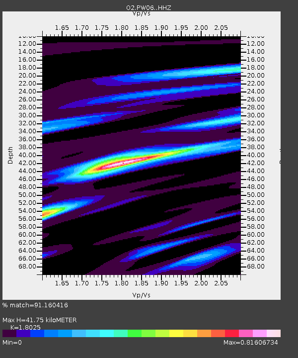
| Estimated Moho Depth: |
41.75 km |
| Estimated Crust Vp/Vs: |
1.80 |
| Assumed Crust Vp: |
6.483 km/s |
| Estimated Crust Vs: |
3.596 km/s |
| Estimated Crust Poisson's Ratio: |
0.28 |
|
| Radial Match: |
91.160416 % |
| Radial Bump: |
319 |
| Transverse Match: |
74.64207 % |
| Transverse Bump: |
400 |
| SOD ConfigId: |
24334971 |
| Insert Time: |
2021-05-15 01:55:20.382 +0000 |
| GWidth: |
2.5 |
| Max Bumps: |
400 |
| Tol: |
0.001 |
|

Signal To Noise
| Channel | StoN | STA | LTA |
| O2:PW06: :HHZ:20210501T01:39:43.265015Z | 13.362818 | 1.6828659E-6 | 1.2593645E-7 |
| O2:PW06: :HHN:20210501T01:39:43.265015Z | 3.024121 | 3.2555792E-7 | 1.0765373E-7 |
| O2:PW06: :HHE:20210501T01:39:43.265015Z | 3.3789814 | 4.082195E-7 | 1.208114E-7 |
| Arrivals |
| Ps | 5.3 SECOND |
| PpPs | 18 SECOND |
| PsPs/PpSs | 23 SECOND |


